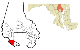
Lochearn (Maryland)
Contenu soumis à la licence CC-BY-SA. Source : Article Lochearn (Maryland) de Wikipédia en français (auteurs)
Regardez d'autres dictionnaires:
Lochearn (Maryland) — Lochearn CDP de los Estados Unidos … Wikipedia Español
Lochearn, Maryland — Infobox Settlement official name = Lochearn, Maryland settlement type = CDP nickname = motto = imagesize = image caption = image imagesize = image caption = image mapsize = 250x200px map caption = Location of Lochearn, Maryland mapsize1 = map… … Wikipedia
Maryland locations by per capita income — Maryland is the wealthiest state in the United States of America, with a median household income of $69,272 according to the 2010 census.[1] Per capita income was $25,615 in 2000 and personal per capita income was $37,331 in 2003. Maryland… … Wikipedia
Lochearn — Lochearn, MD U.S. Census Designated Place in Maryland Population (2000): 25269 Housing Units (2000): 10229 Land area (2000): 5.569402 sq. miles (14.424685 sq. km) Water area (2000): 0.021841 sq. miles (0.056569 sq. km) Total area (2000): 5.591243 … StarDict's U.S. Gazetteer Places
Lochearn, MD — U.S. Census Designated Place in Maryland Population (2000): 25269 Housing Units (2000): 10229 Land area (2000): 5.569402 sq. miles (14.424685 sq. km) Water area (2000): 0.021841 sq. miles (0.056569 sq. km) Total area (2000): 5.591243 sq. miles… … StarDict's U.S. Gazetteer Places
Maryland State House — U.S. National Register of Historic Places U.S. National Historic Landmark … Wikipedia
Maryland Route 26 — Liberty Road, Liberty Heights Avenue … Wikipedia
Maryland State Commission on Criminal Sentencing Policy — Maryland State Commission on Criminal Sentencing Policy, (MSCCSP), is an agency within the state government of Maryland, that sets guidelines which are used by Maryland circuit court judges in sentencing persons convicted of crimes in the state.… … Wikipedia
Maryland Line, Maryland — Maryland Line Unincorporated town … Wikipedia
Maryland — This article is about the U.S. state of Maryland. For other uses, see Maryland (disambiguation). State of Maryland … Wikipedia
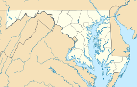
 États-Unis
 Maryland