London Borough de Bexley
- London Borough de Bexley
-
Bexley (district londonien)
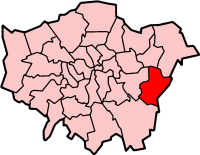
Le district londonien de Bexley (« London Borough of Bexley ») est un district du Grand Londres. Cette circonscription fut fondée en 1965 par fusion des districts du Kent, de Bexley, Erith et Crayford avec la moitié du district métropolitain de Chislehurst and Sidcup. Ce district compte plus de 219 000 habitants.
Ce district est composé de :
- Albany Park
- Barnehurst
- Barnes Cray
- Belvedere
- Bexley
- Bexleyheath
- Blackfen
- Blendon
- Bostall
- Bridgen
- Coldblow
- Crayford
- Crook Log
- East Wickham
- Erith
- Falconwood
- Foots Cray
- Lamorbey
- Lessness Heath
- Longlands
- May Place
- North Cray
- North End
- Northumberland Heath
- Old Bexley
- Sidcup
- Slade Green
- Thamesmead
- Upper Belvedere
- Upton
- Welling
- West Heath
 Portail de Londres
Catégories : District londonien | Bexley (district londonien)
Wikimedia Foundation.
2010.
Contenu soumis à la licence CC-BY-SA. Source : Article London Borough de Bexley de Wikipédia en français (auteurs)
Regardez d'autres dictionnaires:
London Borough of Bexley — Lage in Greater London Status London Borough Region … Deutsch Wikipedia
London Borough of Bexley — Infobox London Borough | name = London Borough of Bexley short name = Bexley adminhq = Broadway, Bexleyheath imagename = status = London borough | area rank = 289th area km2 = 60.56 ons code = 00AD | url = [http://www.bexley.gov.uk/ LB Bexley]… … Wikipedia
London Borough of Greenwich — Infobox London Borough | name = London Borough of Greenwich motto = We Govern by Serving short name = Greenwich imagename = status = London borough | area rank = 302nd area km2 = 47.35 ons code = 00AL | adminhq = Woolwich | ethnicity = 72.1%… … Wikipedia
London Borough of Havering — Infobox London Borough | name = London Borough of Havering short name = Havering adminhq = Main Road, Romford imagename = status = London borough | area rank = 231st area km2 = 112.27 | area link = 1 E8 m² ons code = 00AR | ethnicity = 93.2%… … Wikipedia
London Borough of Barking and Dagenham — Infobox London Borough | name = London Borough of Barking and Dagenham motto = short name = Barking and Dagenham adminhq = Rainham Road North, Becontree Heath imagename = status = London borough | area rank = 327th area km2 = 36.09 ons code =… … Wikipedia
Municipal Borough of Bexley — Bexley Motto: Non Nobis Sed Communitati (Not for ourselves but for the community) Geography Status Local board (1879 1894) Urban district (1894 1935) Municipal borough (after 1935) … Wikipedia
London Borough of Southwark — London borough Coat of arms … Wikipedia
London Borough of Harrow — London borough Coat of arms … Wikipedia
London Borough of Merton — London borough Coat of arms … Wikipedia
London Borough of Tower Hamlets — Lage in Greater London Status London Borough Region … Deutsch Wikipedia