Lostorf
- Lostorf
-
| Lostorf |
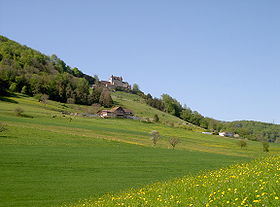
Vue du château de Wartenfels |
| Administration |
| Pays |
Suisse |
 |
| Canton |
Soleure |
| District |
Gösgen |
| Langue |
Allemand |
| N° OFS |
2493 |
| Code postal |
4654 |
| Site Web |
www.lostorf.ch |
| Géographie |
| Superficie |
13,26 km²[1] |
| Altitude |
451 |
| Coordonnées |
47° 23′ 05″ N 7° 57′ 00″ E / 47.384721, 7.95000247° 23′ 05″ N 7° 57′ 00″ E / 47.384721, 7.950002 |
Communes limitrophes
(voir carte) |
Rohr, Stüsslingen, Niedergösgen, Obergösgen, Winznau, Trimbach, Wisen, Zeglingen |
| Démographie |
| Population |
3 782 (31 décembre 2009)[2] |
| Densité |
285,2 hab./km² |
| Localisation |
|
Localisation de Lostorf en Suisse.
|
modifier  |
Lostorf est une commune suisse du canton de Soleure, située dans le district de Gösgen.
Références
Sur les autres projets Wikimedia :
Wikimedia Foundation.
2010.
Contenu soumis à la licence CC-BY-SA. Source : Article Lostorf de Wikipédia en français (auteurs)
Regardez d'autres dictionnaires:
Lostorf — Basisdaten Staat: Schweiz Kanton … Deutsch Wikipedia
Lostorf — Escudo … Wikipedia Español
Lostorf — Lostorf, Pfarrdorf im Amte Olten Gösgen des Schweizercantons Solothurn; Schloß Wartenfels, Gypsgruben, Marmorbruch; 1100 Ew. Dabei das gleichnamige Bad (seit 1412 bekannt, 1810 die Badeanstalt erweitert u. verschönert); die kalte Mineralquelle… … Pierer's Universal-Lexikon
Lostorf — Infobox Swiss town subject name = Lostorf municipality name = Lostorf municipality type = municipality imagepath coa = Lostorf blason.png|pixel coa= languages = German canton = Solothurn iso code region = CH SO district = Gösgen lat d=47|lat… … Wikipedia
Lostorf — Original name in latin Lostorf Name in other language Lostorf State code CH Continent/City Europe/Zurich longitude 47.38445 latitude 7.94849 altitude 443 Population 3749 Date 2013 03 01 … Cities with a population over 1000 database
Lostorf — Lọstorf, Gemeinde im Kanton Solothurn, Schweiz, nordöstlich von Olten, am Südfuß des Jura, 453 m über dem Meeresspiegel, 3 100 Einwohner; mit Thermalbad (Bad Lostorf, Calciumsulfatthermen von 27 ºC; Ersterwähnung 1412, heutige Anlagen von 1971 … Universal-Lexikon
Stüßlingen — Stüsslingen Basisdaten Kanton: Solothurn Bezirk: Gösgen … Deutsch Wikipedia
Bezirk Gösgen — Basisdaten Kanton: Solothurn Hauptort: Niedergösgen BFS Nr.: 1105 Fläche: 68.81 km² Einwohner … Deutsch Wikipedia
Rohr (SO) — SO dient als Kürzel für den Schweizer Kanton Solothurn und wird verwendet, um Verwechslungen mit anderen Einträgen des Namens Rohr zu vermeiden. Rohr (SO) … Deutsch Wikipedia
Stüsslingen — Basisdaten Staat: Schweiz Kanton … Deutsch Wikipedia
 Lostorf