Louisville Waterfront Park
- Louisville Waterfront Park
-
38°15′33.73″N 85°44′46.72″O / 38.2593694, -85.7463111

Le
Louisville Waterfront Park
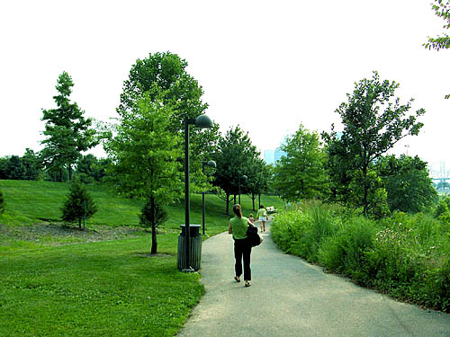
Le Louisville Waterfront Park est un parc municipal de 29,2 ha situé dans le quartier de Downtown à Louisville en bordure de la rivière Ohio.
Histoire
La première phase de construction du parc fut achevée le 4 juillet 1999 avec une superficie d'environ 22,3 ha. Le parc fut dessiné par un bureau local d’architectes. Le coût initial avoisinait les 58 millions de dollars[1]. Avant, le site était constitué de friches industrielles. Le parc est le théâtre de concerts et de divers festivals tout au long de l'année et accueille ainsi plus d'un million de visiteurs chaque année.
La seconde phase du parc se termina le 10 juin 2004 et ajouta au parc une surface d'environ 6,9 ha. Le parc abrite ainsi un amphithéâtre, un quai pour accueillir des bateaux de touristes en provenance de la rivière Ohio et différents locaux de l'université de Louisville. Le parc offre également une connexion Wi-Fi gratuite. Chaque année, le parc accueille un feu d'artificle lors du festival du Kentucky Derby.
Une troisième phase devrait voir la transformation du pont ferroviaire (‘’Big Four Bridge’’) sur l’Ohio en un pont pour piétons.
Références
- ↑ (en)Shafer, Sheldon : Holiday events will showcase Waterfront Park, The Courier-Journal (1999-02-01).
Liens externes
Wikimedia Foundation.
2010.
Contenu soumis à la licence CC-BY-SA. Source : Article Louisville Waterfront Park de Wikipédia en français (auteurs)
Regardez d'autres dictionnaires:
Louisville Waterfront Park — Infobox park park=Louisville Waterfront Park image size=250px caption=The Louisville Waterfront Park exhibits rolling hills, spacious lawns and walking paths on Louisville s waterfront in the downtown area type=Municipal park location=Downtown… … Wikipedia
Waterfront Park — can refer to any of a number of parks on a river or other body of water, including:*Tom McCall Waterfront Park along the Willamette River in Portland, Oregon. *Louisville Waterfront Park along the Ohio River in Louisville, Kentucky, which opened… … Wikipedia
Louisville, Kentucky — Louisville redirects here. For other uses, see Louisville (disambiguation). Louisville Consolidated city county Louisville Jefferson County Metro Government … Wikipedia
Louisville, Kentucky — Louisville (Kentucky) Pour les articles homonymes, voir Louisville. Louisville … Wikipédia en Français
Waterfront Development Corporation — The Waterfront Development Corporation (WDC) of Louisville, Kentucky is a non profit/stock corporation created by the Kentucky General Assembly in 1986.For many years before the Waterfront Development Corporation s founding in 1986 political… … Wikipedia
Louisville (Kentucky) — Pour les articles homonymes, voir Louisville. 38° 15′ 15″ N 85° 45′ 37″ W … Wikipédia en Français
Louisville Loop — The Louisville Loop is a bike and pedestrian trail which will circle the city of Louisville, Kentucky when completed. It is part of a project known as City of Parks, which will also add thousands of acres of parkland in the city, using the trail… … Wikipedia
Downtown Louisville — Coordinates: 38°15′28.21″N 85°45′41.99″W / 38.2578361°N 85.7616639°W / 38.2578361; 85.7616639 … Wikipedia
History of Louisville, Kentucky — The history of Louisville, Kentucky spans hundreds of years, and has been influenced by the area s unique geography and location.Pre settlement history (pre 1778)Although Kentucky was inhabited by Native Americans in prehistoric times, when white … Wikipedia
Shawnee Park — Infobox Park park = Shawnee Park image size = 200px caption = Pond and Shelter in Shawnee Park type = Urban park location = West Louisville, Kentucky coordinates = size = 316 acres opened = 1892 operator = Louisville Metro Parks visitors = status … Wikipedia