- Mannekensvere
-
Mannekensvere 

Administration Pays  Belgique
Région  Région flamande
Communauté Communauté flamandeProvince  Province de Flandre-Occidentale
Arrondissement Ostende Commune Middelkerke Géographie Coordonnées Superficie 6,58 km² Population ? hab. (date inconnue) Densité ? hab./km² Autres informations Gentilé Code postal 8433 Zone téléphonique 059 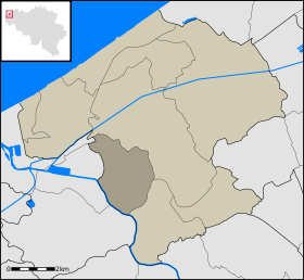
Localisation de Mannekensvere au sein de Middelkerkemodifier 
Mannekensvere est une section de la commune belge de Middelkerke située en Région flamande dans la province de Flandre-Occidentale.
Catégorie :- Commune avant fusion de l'arrondissement d'Ostende


Wikimedia Foundation. 2010.