- Marlik
-
Marlik
Cheragh-Ali Tepe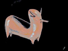
Rhyton MarlikLocalisation Pays  Iran
IranProvince Gilan Coordonnées [1] 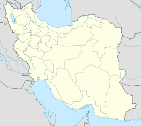
 Marlik
Marlik est un site archéologique d'Iran (Gilan, au nord du pays). De nombreux objets de l'antiquité y ont été trouvés : Une étonnante série d'art primitif représentant des animaux (taureau, léopard, dromadaire...) avec des lignes épurées, très stylées datant autour du XIIIe siècle av. J.‑C.. Des gobelets en or gravé de monstres : hommes-taureaux...
Notes et références
- Coordonnées approximatives d'après les croquis dans (en) ʻIzzat Allāh Nigāhbān, Marlik: the complete excavation report (2 volumes), University of Pennsylvania Museum of Archaeology, 1996, 408 p. (ISBN 9780924171321) [lire en ligne] [présentation en ligne], p. lii
Annexes
Liens externes
- (en) The magic of Marlik sur iranian.com
- Vase décoré de taureaux et de chevaux en haut relief sur Musée du Louvre
- Gobelet à décor de monstres entrelacés sur Musée du Louvre
- Vase en forme de taureau à bosse sur Musée du Louvre
- (en) Charles K. Wilkinson, « Art of the Marlik Culture » sur The Metropolitan Museum of Art.
- Marlik sur Clio la Muse
- (en) Marlik Archaeological Region sur Iran Toursim and Touring Online
Bibliographie
- Guy Rachet, Dictionnaire de l'archéologie, Robert Laffont, coll. « Bouquins », 1994, 1060 p. (ISBN 9782221079041), « Marlik », p. 584
- (en) ʻIzzat Allāh Nigāhbān, Marlik: the complete excavation report (2 volumes), University of Pennsylvania Museum of Archaeology, 1996, 408 p. (ISBN 9780924171321) [présentation en ligne]
Catégories :- Site archéologique d'Iran
- Néolithique du Proche-Orient


Wikimedia Foundation. 2010.