McAlpine Locks and Dam
- McAlpine Locks and Dam
-
38° 16′ 41″ N 85° 47′ 32″ W / 38.27810, -85.79220
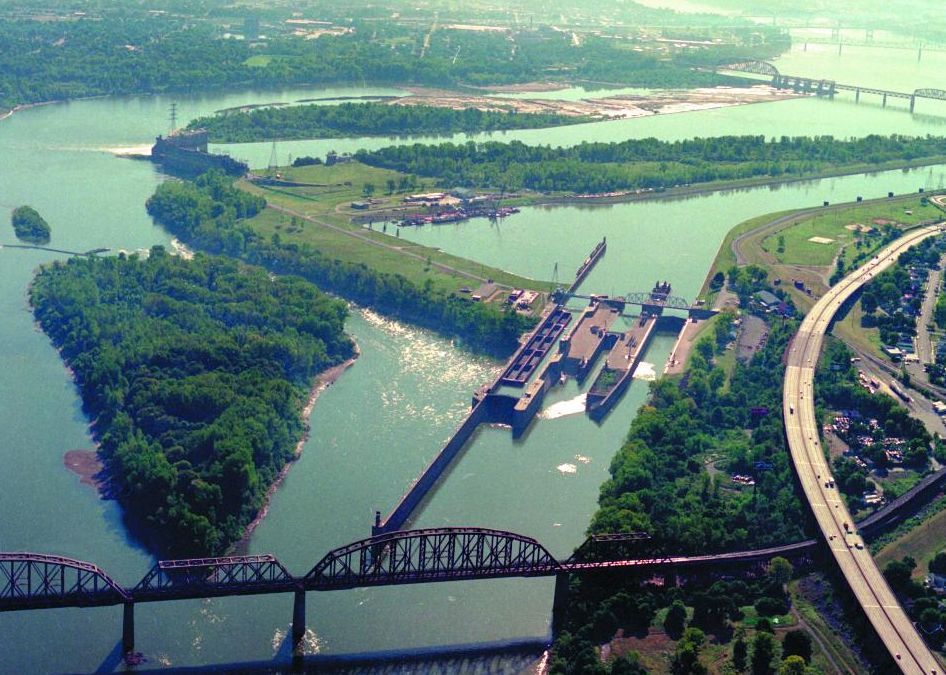
Le McAlpine Locks and Dam est un système composé d'un barrage hydroélectrique et de plusieurs écluses sur la rivière Ohio au niveau de la ville de Louisville dans l'État du Kentucky.
Terminé en 1830, le premier nom officiel de l'ensemble fut Louisville and Portland Canal. Un barrage hydroélectrique s'ajoute à l'ensemble entre 1925 et 1927 et le canal est élargi en partie par le corps des ingénieurs de l'armée des États-Unis. A l'époque, il s'agit de la septième plus grande installation hydroélectrique du pays.
Le système est renommé en 1960 en hommage à William McAlpine qui était le seul civil à avoir travaillé en tant qu'ingénieur de district du corps des ingénieurs de Louisville. Le canal est situé à 130 mètres au-dessus du niveau de la mer. Le débit moyen s'écoulant dans le système est de 3 340 m³/s. Les écluses, situées sur la rive du côté du Kentucky permettent de franchir un dénivelé de 11 mètres.
Le barrage est composé de huit turbines générant une puissance totale de 80 MW. Des travaux de restauration terminés en 2008 vise à donner à la centrale une puissance totale de 100 MW. La centrale électrique appartient à LG&E qui est une succursale de la société allemande E.ON.
Notes et références
Wikimedia Foundation.
2010.
Contenu soumis à la licence CC-BY-SA. Source : Article McAlpine Locks and Dam de Wikipédia en français (auteurs)
Regardez d'autres dictionnaires:
McAlpine Locks and Dam — Coordinates: 38°16′41″N 85°47′32″W / 38.27810°N 85.79220°W / 38.27810; 85.79220 … Wikipedia
Cannelton Locks and Dam — Infobox Dam dam name=Cannelton Locks and Dam caption= official name= crosses=Ohio River reservoir= locale= maint=United States Army Corps of Engineers Louisville District length=1,827 ft (556.9 m) height= width= began=July 1963 open=December 1966 … Wikipedia
List of reservoirs and dams in the United States — There are an estimated 75,000 dams in the United States, blocking 600,000 miles (960,000 km) of river or about 17% of rivers in the nation . [cite web|url=http://www.pcffa.org/dams.htm |title=Dams and salmon |accessdate=2008 02 11] The following… … Wikipedia
Louisville and Portland Canal — The Louisville and Portland Canal was a convert|2|mi|km|sing=on canal bypassing the Falls of the Ohio in the Ohio River near Louisville, Kentucky. It opened in 1830, and was operated by the Louisville and Portland Canal Company until 1874, and… … Wikipedia
List of dams and reservoirs in the United States — This list is incomplete; you can help by expanding it. The following is a partial list of dams and reservoirs in the United States. There are an estimated 75,000 dams in the United States, impounding 600,000 mi (970,000 km) of river or about 17%… … Wikipedia
Ohio River — Valley redirects here. For the American wine region that spans the valley, see Ohio River Valley AVA. Coordinates: 36°59′12″N 89°07′50″W / 36.98667°N 89.13056°W … Wikipedia
Inland waterways of the United States — The inland waterways of the United States include over 25,000 miles (40000 km) of navigable waters. Much of the commercially important waterways of the United States consist of the Mississippi River System mdash;the Mississippi River and… … Wikipedia
Bowman Field — Louisville (Kentucky) Pour les articles homonymes, voir Louisville. Louisville … Wikipédia en Français
Kentuckiana — Louisville (Kentucky) Pour les articles homonymes, voir Louisville. Louisville … Wikipédia en Français
Louisville, Kentucky — Louisville (Kentucky) Pour les articles homonymes, voir Louisville. Louisville … Wikipédia en Français