Mihajlovo

Mihajlovo
Mihajlovo
Михајлово, Szentmihály
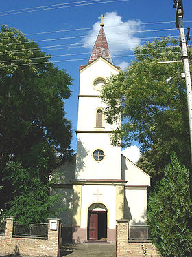
L'église catholique Saint-Michel-Archange à Mihajlovo
Administration
Pays Drapeau de Serbie Serbie
Province Voïvodine
Région Banat serbe
District Banat central
Ville Zrenjanin
Code postal 23 202
Géographie
Coordonnées 45° 28′ 13″ Nord
       20° 24′ 52″ Est
/ 45.4703, 20.4144
Altitude 70 m
Superficie 1 940 ha = 19,4 km2
Démographie
Population 1 004 hab. (2002)
Densité 51,8 hab./km2
Localisation
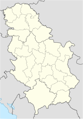
Serbia location map.svg
City locator 14.svg
Mihajlovo

Mihajlovo (en serbe cyrillique : Михајлово ; en hongrois : Szentmihály) est une localité de Serbie située dans la province autonome de Voïvodine et sur le territoire de la Ville de Zrenjanin, district du Banat central. En 2002, elle comptait 1 004 habitants[1], dont une majorité de Hongrois.

Mihajlovo est officiellement classé parmi les villages de Serbie.

Sommaire

Géographie

Histoire

Démographie

Évolution historique de la population

Évolution démographique
1948 1953 1961 1971 1981 1991 2002
1 373 1 286 1 409 1 252 1 318 1 169 1 004[1]

Répartition de la population (2002)

Nationalité Nombre %
Hongrois 944 94,02
Serbes 37 3,68
Roumains 6 0,59
Yougoslaves 4 0,39
Croates 1 0,09
Slovènes 1 0,09
Slovaques 1 0,09
Roms 1 0,09
Inconnus/Autres[2]

Économie

Notes et références

  1. a et b (sr) Livre 9, Population, analyse comparative de la population en 1948, 1953, 1961, 1971, 1981, 1991 et 2002, données par localités, Institut de statistique de la République de Serbie, Belgrade, mai 2004 (ISBN 86-84433-14-9)
  2. (sr) Livre 1, Population, origine nationale ou ethnique, données par localités, Institut de statistique de la République de Serbie, Belgrade, février 2003 (ISBN 86-84433-00-9)

Voir aussi

Sur les autres projets Wikimedia :

Articles connexes

Liens externes


Wikimedia Foundation. 2010.

Contenu soumis à la licence CC-BY-SA. Source : Article Mihajlovo de Wikipédia en français (auteurs)

Игры ⚽ Нужно сделать НИР?

Regardez d'autres dictionnaires:

  • Mihajlovo — Saint Michael the Archangel Catholic Church. Mihajlovo (Михајлово, Hungarian: Magyarszentmihály) is a village in Serbia. It is located in the Zrenjanin municipality, in the Central Banat District, Vojvodina province. The village has a Hungarian… …   Wikipedia

  • Mihajlovo — Original name in latin Mihajlovo Name in other language Magyarszentmihaly, Magyarszentmihly, Mihajlovo, Szentmihaly, Szentmihly State code RS Continent/City Europe/Belgrade longitude 45.47085 latitude 20.41508 altitude 77 Population 1318 Date… …   Cities with a population over 1000 database

  • Zrenjanin — Зрењанин   City   City Hall and monument of king Peter I of Serbia …   Wikipedia

  • Zrenjanin — Pour les articles homonymes, voir Zrenjanin (homonymie). Zrenjanin Зрењанин …   Wikipédia en Français

  • Novi Bečej — Нови Бечеј   Municipality and Town   Serbian Orthodox church in Novi Bečej …   Wikipedia

  • Nova Crnja — Нова Црња Magyarcsernye   village   The Saint Agatha Virgin and Martyr Catholic Church …   Wikipedia

  • Žitište — Житиште Bégaszentgyörgy   Municipality and Town   Building in town center …   Wikipedia

  • Sečanj — Сечањ   village   The new Orthodox church …   Wikipedia

  • List of cities, towns and villages in Vojvodina — This is a list of cities, towns and villages in Vojvodina, a province of Serbia. Largest cities of Vojvodina are: Novi Sad (216,583), Subotica (99,981), Zrenjanin (79,773), Pančevo (77,087), Sombor (51,471), Kikinda (41,935), Sremska Mitrovica… …   Wikipedia

  • Međa (Žitište) — Coordinates: 45°32′09″N 20°48′25″E / 45.53583°N 20.80694°E / 45.53583; 20.80694 …   Wikipedia

Share the article and excerpts

Direct link
Do a right-click on the link above
and select “Copy Link”