Mohall

Mohall

48° 45′ 54″ N 101° 30′ 40″ W / 48.765000, -101.511111

Mohall
Devise : « Beautiful Town, Beautiful People »
Administration
Pays Drapeau des États-Unis États-Unis
État Dakota du Nord Dakota du Nord
Comté Renville
Maire Bonnie Locken
Code FIPS 38-53780
GNIS 1030268
Code ZIP 58761
Indicatif téléphonique local 701
Site web Consulter
Historique
Fondation 1901
Démographie
Population (2010) 783 hab.
Densité 280 hab./km²
Géographie
Coordonnées 48° 45′ 54″ Nord
       101° 30′ 40″ Ouest
/ 48.765000, -101.511111
Altitude 500 m
Superficie totale 2,8 km2
· dont terre 2,8 km2 (100 %)
· dont eau 0 km2 (0 %)
Fuseau horaire CST (UTC-6)
Voir la carte administrative
City locator 14.svg
Voir la carte topographique
City locator 14.svg

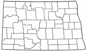
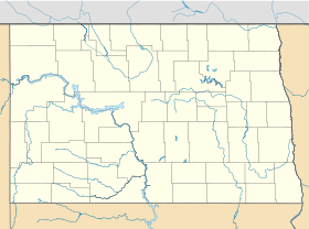
La ville de Mohall est le siège du comté de Renville, dans l’État du Dakota du Nord, aux États-Unis. Lors du recensement de 2010, sa population s’élevait à 783 habitants. Superficie totale : 2,8 km² (1,1 mi²). Coordonnées géographiques : 48°45′54″N 101°30′40″O / 48.765, -101.51111.

Histoire

Mohall a été fondée en 1901 par M. O. Hall, un homme d’affaires originaire de Duluth qui a donné son nom à la localité. Mais il existait déjà un autre Hall dans l’État aussi elle a été renommée Mohall en 1902. Elle est devenue le siège du comté en 1910, quand le comté a été créé par division du comté de Ward.

Source


Wikimedia Foundation. 2010.

Contenu soumis à la licence CC-BY-SA. Source : Article Mohall de Wikipédia en français (auteurs)

Игры ⚽ Нужно решить контрольную?

Regardez d'autres dictionnaires:

  • Mohall — Mohall, ND U.S. city in North Dakota Population (2000): 812 Housing Units (2000): 397 Land area (2000): 1.085768 sq. miles (2.812127 sq. km) Water area (2000): 0.000000 sq. miles (0.000000 sq. km) Total area (2000): 1.085768 sq. miles (2.812127… …   StarDict's U.S. Gazetteer Places

  • Mohall, ND — U.S. city in North Dakota Population (2000): 812 Housing Units (2000): 397 Land area (2000): 1.085768 sq. miles (2.812127 sq. km) Water area (2000): 0.000000 sq. miles (0.000000 sq. km) Total area (2000): 1.085768 sq. miles (2.812127 sq. km) FIPS …   StarDict's U.S. Gazetteer Places

  • Mohall — Original name in latin Mohall Name in other language State code US Continent/City America/Chicago longitude 48.76336 latitude 101.51322 altitude 501 Population 783 Date 2011 05 14 …   Cities with a population over 1000 database

  • Mohall — Sp Mòholas Ap Mohall L JAV Renvilio apyg. c. (Š. Dakota) …   Pasaulio vietovardžiai. Internetinė duomenų bazė

  • Mohall, North Dakota —   City   Motto: Beautiful Town, Beautiful People. Location of …   Wikipedia

  • Mohall (Dakota del Norte) — Mohall Ciudad de los Estados Unidos …   Wikipedia Español

  • Mohall Lansford Sherwood School District — The Mohall Lansford Sherwood (MLS) School District is a system of publicly funded schools serving the cities of Mohall, Lansford, and Sherwood, and the surrounding rural areas. It is in North Dakota region 6, district 12. There are two K 12… …   Wikipedia

  • 58761 — Mohall, Nd (Miscellaneous » ZIP Codes) …   Abbreviations dictionary

  • Northern Plains Railroad — Reporting mark NPR Locale Northern North Dakota and Northwest Minnesota Dates of operation 1997– …   Wikipedia

  • Northern Plains Railroad — Logo der Northern Plains Railroad Streckennetz der Northern Plains Rai …   Deutsch Wikipedia

Share the article and excerpts

Direct link
Do a right-click on the link above
and select “Copy Link”