Ap Lei Chau
- Ap Lei Chau
-
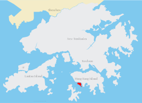
Ap Lei Chau (Sinogramme traditionnel : 鴨脷洲) ou Aberdeen Island est une île de Hong Kong, située au sud-ouest de l'île de Hong Kong, à proximité de Aberdeen. Administrativement, elle fait partie du district du Sud. Avec une superficie de 1,32 km2 et une population estimée à 86 782, Ap Lei Chau est l'une des îles les plus densément peuplées au monde. Le pont Ap Lei Chau relie l'île à l'île de Hong Kong.
Sur les autres projets Wikimedia :
Wikimedia Foundation.
2010.
Contenu soumis à la licence CC-BY-SA. Source : Article Ap Lei Chau de Wikipédia en français (auteurs)
Regardez d'autres dictionnaires:
Ap Lei Chau — (zh tcy|t=鴨脷洲|cy=aap3 lei6 jau1), or Aberdeen Island, is an island of Hong Kong, located south west of Hong Kong Island, next to Aberdeen Harbour and Aberdeen Channel, with an area of 1.32 km². Administratively, it is part of Southern District.… … Wikipedia
Ap Lei Chau — Vorlage:Infobox Insel/Wartung/Höhe fehlt Ap Lei Chau Mount Johnston auf Ap Lei Chau Gewässer … Deutsch Wikipedia
Public housing estates in Pok Fu Lam, Aberdeen and Ap Lei Chau — The following shows the public housing estates (including Home Ownership Scheme (HOS), Private Sector Participation Scheme (PSPS), Tenants Purchase Scheme (TPS) and Sandwich Class Housing Scheme (SCHS)) in Pok Fu Lam, Aberdeen and Ap Lei Chau of… … Wikipedia
Bridal Tea House Ap Lei Chau Main Street — (Гонконг,Гонконг) Категория отеля: 3 звездочный отель Адрес … Каталог отелей
Ap Lei Chau Bridge — (zh tspcy|t=鴨脷洲大橋|s=鸭脷洲大桥|p=Yālìzhōu Dàqiáo|cy=ngaap3 lei6 jau1 daai6 kiu4) is a highway bridge in Hong Kong connecting the island of Ap Lei Chau and Aberdeen of the Hong Kong Island acrossing the . This bridge was made up of two lanes for each… … Wikipedia
Chau Tsai Kok — (Chinese: 洲仔角) is a small uninhabited island off the island of Tap Mun in the northeastern New Territories of Hong Kong, opposite to the village of Tap Mun. It is under the administration of Tai Po District … Wikipedia
Lei Tung Station — Lei Tung will be an MTR station located on Ap Lei Chau, Hong Kong, on the the HK MTR lines|South Island East. It is named after a housing estate Lei Tung Estate. Entrances/exits Lei Tung Station will have three exits. MTR proposed that some of… … Wikipedia
Chau Tsai — Map of Chan Tsai and Nam Wan Kok, Tsing Yi Islands before reclamation Chau Tsai (Chinese: 洲仔) was a small island off the southern shore, Nam Wan Kok, of Tsing Yi Island of Hong Kong. It was also known as Chun Fa Rock (Chung Hue Rock), or Chung… … Wikipedia
Chau Tau Station — Chau Tau 洲頭 … Wikipedia
Tung Lung Chau — Map of Hong Kong showing the location of Tung Lung Chau. The cliffs on the east coast of … Wikipedia
 Chine
Chine