Nathula
- Nathula
-
Nathu La
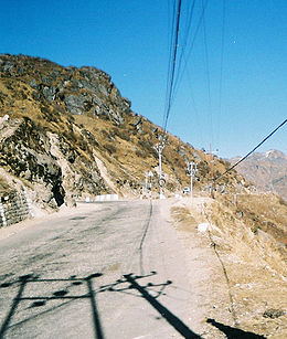
Le Nathu La est un col de montagne qui relie la région du Sikkim en Inde au Tibet. Il culmine à 4310 mètres d'altitude. Littéralement Nathu La signifie la passe de l'oreille qui écoute.
L'ancienne route de la soie passait par le Nathu la. Cela reste l'accès terrestre le plus direct entre les villes importantes du Tibet (Lhassa et Shigatse) et la mer (le port de Calcutta sur le Hooghly). Le col avait été fermé provisoirement en 1959, après la révolte sanglante des Tibétains à Lhassa. Puis définitivement en 1962 après l'incursion en Inde faite par les troupes chinoises. Il fut rouvert le 6 juillet 2006.
Liens externes
 Portail de la montagne
 Portail du monde indien
 Portail du Tibet
Catégories : Col d'Inde | Col de République populaire de Chine
Wikimedia Foundation.
2010.
Contenu soumis à la licence CC-BY-SA. Source : Article Nathula de Wikipédia en français (auteurs)
Regardez d'autres dictionnaires:
Nathu La — Stairs leading to the border on the Indian side Elevation 4,310 m (14,140 ft) … Wikipedia
Sino-Indian relations — China India relations India … Wikipedia
Gangtok — Infobox Indian Jurisdiction native name=Gangtok type=capital |skyline = Gangtok.jpg skyline caption = Gangtok as viewed from the opposite hill locator position=left latd = 27.33 | longd = 88.62 state name=Sikkim district=East Sikkim leader… … Wikipedia
East Sikkim — is one of the four administrative districts of the Indian state of Sikkim. Geographically, East Sikkim occupies the south east corner of the state. The capital of East Sikkim is Gangtok, which is also the state capital. It is the hub of all… … Wikipedia
Baba Harbhajan Singh — View inside the shrine of Baba Harbhajan Singh Captain Baba Harbhajan Singh (August 3, 1941 – October 4, 1968) (Punjabi: ਹਰਭਜਨ ਸਿੰਘ) was an Indian army soldier who died near the Nathula Pass in eastern Sikkim, India. He is revered by the soldiers … Wikipedia
Sikkim — For other uses, see Sikkim (disambiguation). Sikkim འབྲས་མོ་ལྗོངས་ सिक्किम S … Wikipedia
Kalimpong — Infobox Indian Jurisdiction native name=Kalimpong type=city locator position=left latd = 27.06|longd=88.47 state name=West Bengal district=Darjeeling leader title=Mayor leader name= ndash; altitude=1247 population as of = 2001 | population total … Wikipedia
History of Sikkim — Not much is known about Sikkim s ancient history, except for the fact that the first inhabitants were the Lepchas or Rong (ravine folk). They were later encompassed and absorbed by other clans. Sikkim also finds its mention on many hindu texts as … Wikipedia
Rajput Regiment — Infobox Military Unit unit name= The Rajput Regiment caption=The Rajput Regiment Insignia dates= 1778 Present country= India allegiance= branch= Army type= Line Infantry role= size=20 Battalions command structure= garrison=Fategarh, Uttar Pradesh … Wikipedia
Shipki La — Infobox Mountain Pass Name = Shipkila Photo = Caption = Elevation = Location = CHN / IND Range = Coordinates = Topographic Traversed by = Indian National Highway 22Shipkila is a mountain pass and border post on the India China border.It is… … Wikipedia
 Inde
Inde Chine
Chine