Northmavine
- Northmavine
-
60°30′N 1°24′W / 60.5, -1.4
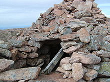
Les restes d'anciennes tours d'observations, de tumulus et de forts sont nombreux. Cette tombe du
Néolithique se trouve sur
Ronas Hill, point le plus haut des Shetland.
Northmavine est une presqu'île britannique de l'île de Mainland, dans l'océan Atlantique, relevant de l'archipel écossais des Shetland.
Cette presqu'île se trouve au nord ouest de Mainland, et contient les villages de Hillswick, Ollaberry et North Roe. De nombreuses îles adjacentes sont rattachées à ce territoire administratif qui mesure 25 km par 13 km. Northmavine est reliée à Mainland uniquement par l'isthme de Mavis Grind. De nombreuses baies se découpent dans les côtes de la presqu'île, consistant principalement en de grands rochers abrupts ; il y a également sur la côte ouest de hautes falaises fissurées, pleines de cavernes, ainsi que des récifs, îlots et autres rochers marins. Peu des terres de cette presqu'île sont arables, le terrain étant élevé et ayant ainsi Ronas Hill, point culminant des Shetland.
Voir aussi
Articles connexes
Wikimedia Foundation.
2010.
Contenu soumis à la licence CC-BY-SA. Source : Article Northmavine de Wikipédia en français (auteurs)
Regardez d'autres dictionnaires:
Northmavine — NORTHMAVINE, a parish, in the Mainland district, county of Shetland, 30 miles (N. W. by N.) from Lerwick; containing, with the hamlet of Hillswick, 2504 inhabitants. This is a peninsula of nearly triangular form, joined to the remaining… … A Topographical dictionary of Scotland
Northmavine — The chambered cairn on Ronas Hill Northmavine (Old Norse: Norðan Mæfeið, meaning the land North of the Mæfeið isthmus (Mavis Grind) ) is a peninsula of Shetland in Scotland. It is in the north west of the island, and contains the villages of… … Wikipedia
Uyea, Northmavine — Infobox Scottish island latitude=60.62 longitude= 1.43 GridReference=HU313929 celtic name= norse name= ve øy meaning of name= possibly Old Norse for island of the sacred place area=45 area rank=200= highest elevation=70 m Population= 0 population … Wikipedia
Ronas Hill — or Rönies Hill gbm4ibx|HU305835; appears in various spellings) is the highest point of Mainland, Shetland, and the entire Shetland archipelago.cite book| author=Haswell Smith, Hamish| year=2004| title=The Scottish Islands| location=Edinburgh|… … Wikipedia
Список Шетландских островов — Шетландский архипелаг … Википедия
Shetland — For other uses, see Shetland (disambiguation). Shetland Sealtainn … Wikipedia
Mainland, Shetland — Location OS grid reference … Wikipedia
Brae — Infobox UK place official name= Brae country= Scotland population= 660 [cite web|publisher=Scotland s Census Results Online|title =Comparative Population Profile: Brae Locality | url=http://www.scrol.gov.uk/scrol/browser/profile.jsp?profile=Popula… … Wikipedia
Tom Anderson (fiddler) — Dr. Tom (Tammie) Anderson MBE, (1910 1991) was a renowned Shetland fiddler and teacher. He was affectionately known to his peers as Muckle Tammie (Big Tommy). Dr. Tom Anderson was known to many in Shetland as the saviour of Shetland s musical… … Wikipedia
Esha Ness Lighthouse — Infobox lighthouse|name= Esha Ness Lighthouse location= Northmavine peninsula, Shetland, Scotland caption= coordinates = 60°29.3’N 01°37.6’W yearbuilt = yearlit= 1929 yeardeactivated= automated= 1974 intensity= 46,500 CD elevation= 61 m range= 46 … Wikipedia

 Portail du monde maritime
 Portail de l’Écosse