Olyokma
- Olyokma
-
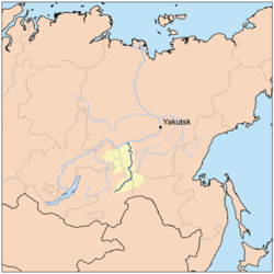
Olekma
L'Olekma ou Oliokma (en russe Олёкма) est une rivière de Sibérie orientale, en Russie d'Asie, et un affluent de la Léna.
Géographie
Elle est longue de 1 436 km.
La rivière prend sa source dans les monts Iablonovy et coule en direction du nord entre les plateaux de Stanovoï à l'ouest et les monts Stanovoï à l'est, jusqu'à ce qu'elle se jette dans la Léna au niveau de l'agglomération de Oliokminsk.
Le bassin de l'Olekma a une superficie de 210 000 km² et son débit moyen est de 1 950 m³/seconde.
L'Olekma traverse les oblasts de Tchita et d'Amour et la république de Sakha (Iakoutie).
Affluents
- Le Toungour (rive droite)
- La Nioukja
- La Tchara (rive gauche) qui se jette dans l'Olekma à peine quinze kilomètres avant la confluence Olekma-Léna, et qui lui apporte quelques 900 m³/seconde.
Notes et références
Liens externes
 Portail de la Russie
 Portail de l’eau
Catégories : Cours d'eau du krai de Transbaïkalie | Cours d'eau de l'oblast d'Amour | Cours d'eau de Sakha | Sibérie | Système hydrologique de la Léna
Wikimedia Foundation.
2010.
Contenu soumis à la licence CC-BY-SA. Source : Article Olyokma de Wikipédia en français (auteurs)
Regardez d'autres dictionnaires:
Olyokma River — The Olyokma River (Russian: Олёкма) is a tributary of the Lena in eastern Siberia. To the west is the Vitim River, to the south the Shilka River and Amur River and to the east, the upper Aldan River. Its right branch, the Tungur (fr:Toungir)… … Wikipedia
Lena River — River, east central Russia, one of the longest rivers in the world. From its source in a Siberian mountain lake west of Lake Baikal, it flows 2,734 mi (4,400 km) north across Russia to enter the Arctic Ocean. Its basin covers an area of 961,000… … Universalium
List of rivers of Russia — Russia can be divided into a European and an Asian part. The dividing line is generally considered to be the Ural Mountains and the Caspian Sea. The European part is drained into the Arctic Ocean, Baltic Sea, Black Sea and Caspian Sea. The Asian… … Wikipedia
Lena River — Infobox River | river name = Lena River caption = Lena watershed origin = Baikal Mountains mouth = Laptev Sea basin countries = Russia length = 4,472 km (2,734 mi) elevation = 1,640 m (5,381 ft) discharge = 17,000 m³/s (600,440 ft³/s) watershed … Wikipedia
Olyokminsk — (English) Олёкминск (Russian) Inhabited locality … Wikipedia
Sakha Republic — Sakha (Yakutia) Republic Республика Саха (Якутия) (Russian) Саха Республиката (Sakha) Republic … Wikipedia
Yerofey Khabarov — Yerofey Pavlovich Khabarov or Svyatitsky ( ru. Ерофей Павлович Хабаров (Святицкий); 1603 mdash; after 1671), was a Russian peasant from Veliky Ustyug region who explored the Lena and Amur rivers. The city of Khabarovsk, a town, and a railway… … Wikipedia
Stanovoy Range — (Russian: Становой хребет, Chinese: 外兴安岭), or Outer Khingan Range is a mountain range located in southeastern parts of the Russian Far East. It runs generally east west from the Olyokma River almost to the Sea of Okhotsk. It separates the… … Wikipedia
Yablonoviy Mountains — Yablonoviy Range ( Яблоновый хребет in Russian) is a mountain range in Transbaikal (mainly in Chita Oblast) in Russia.It stretches for some 650 km from the Malkhansky Range on the west to the mouth of the Nyukzha River (tributary of the Olyokma… … Wikipedia
Tupik — ( ru. Тупик) is a village ( selo ) and administrative center of Tungiro Olyokminsky District of Zabaykalsky Krai, Russia, located on the Olyokma River, km to mi|100 north of Mogocha. Population: 1,041 (2002 Census); 1,069 (1989 Census).Tupik was… … Wikipedia
 Russie