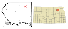
Onaga (Kansas)
Contenu soumis à la licence CC-BY-SA. Source : Article Onaga (Kansas) de Wikipédia en français (auteurs)
Regardez d'autres dictionnaires:
Onaga (Kansas) — Onaga Ciudad de los Estados Unidos … Wikipedia Español
Onaga, Kansas — This article is about the city in Kansas. For other uses, see Onaga (disambiguation). Onaga, Kansas City … Wikipedia
Onaga (disambiguation) — Onaga is a Mortal Kombat character. Onaga may also refer to: Yoshimitsu Onaga, karate instructor Onaga, Kansas, a small town in the United States Onaga, the Hawaiian language name for the fish Lutjanus campechanus also known as ʻUla,ʻula koaʻe or … Wikipedia
Kansas locations by per capita income — Kansas has the twenty sixth highest per capita income in the United States, at $20,506 (2000). Its personal per capita income is $29,935 (2003). TOC Kansas counties ranked by per capita incomeThere are 105 counties located in Kansas, one of which … Wikipedia
Onaga — Onaga, KS U.S. city in Kansas Population (2000): 704 Housing Units (2000): 347 Land area (2000): 0.634695 sq. miles (1.643853 sq. km) Water area (2000): 0.000000 sq. miles (0.000000 sq. km) Total area (2000): 0.634695 sq. miles (1.643853 sq. km)… … StarDict's U.S. Gazetteer Places
Onaga, KS — U.S. city in Kansas Population (2000): 704 Housing Units (2000): 347 Land area (2000): 0.634695 sq. miles (1.643853 sq. km) Water area (2000): 0.000000 sq. miles (0.000000 sq. km) Total area (2000): 0.634695 sq. miles (1.643853 sq. km) FIPS code … StarDict's U.S. Gazetteer Places
National Register of Historic Places listings in Pottawatomie County, Kansas — Location of Pottawatomie County in Kansas This is a list of the National Register of Historic Places listings in Pottawatomie County, Kansas. This is intended to be a complete list of the properties and districts on the National Register of… … Wikipedia
List of high schools in Kansas — This is a list of high schools in the state of Kansas. =Allen County= *Humboldt High School, Humboldt *Iola High School, Iola *Marmaton Valley High School, Moran =Anderson County= *Crest High School, Colony *Anderson County High School, Garnett… … Wikipedia
Condado de Pottawatomie (Kansas) — Para otros usos de este término, véase Condado de Pottawatomie. Condado de Pottawatomie Condado de los Estados Unidos … Wikipedia Español
Pottawatomie County, Kansas — Infobox U.S. County county=Pottawatomie County state=Kansas founded=February 20, 1857 seat=Westmoreland area total km2=2233|area total sq mi=862 area land km2=2187|area land sq mi=844 area water km2=46|area water sq mi=18 area percentage=2.07%… … Wikipedia
 Pour les articles homonymes, voir Onaga.
 États-Unis
 Kansas
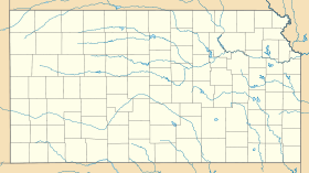