Oreti

Oreti

46° 28′ 00″ S 168° 16′ 59″ E / -46.4667, 168.283

Oreti River
Illustration sous licence libre bienvenue !
NZ-Oreti R.png

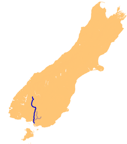
L'Oreti et ses affluents sur une carte de l'île du Sud
Caractéristiques
Longueur 170 km
Bassin  ?
Débit moyen  ?
Cours
Se jette dans Détroit de Foveaux
Géographie
Pays traversés Drapeau de Nouvelle-Zélande Nouvelle-Zélande
Principales villes Invercargill

L'Oreti est un fleuve et l'un des plus longs cours d'eau de la Nouvelle-Zélande.

Géographie

Situé dans le sud de l'île du Sud (dans la région de Southland), il coule sur 170 km. Il puise sa source près des lacs Mavora, entre le lac Te Anau et le lac Wakatipu, avant de continuer au sud dans les plaines de Southland jusqu'à son embouchure au détroit de Foveaux à Oreti Beach. Dans son parcours il passe par les villages de Lumsden et Winton ainsi que la ville d'Invercargill. Parmi ses affluents on trouve le Dipton et le Makarewa.

Autour d'Invercargill et son propre estuaire il est appelé New River, nom occasionnellement utilisé pour faire référence à tout le fleuve.

Source

Notes et références


Wikimedia Foundation. 2010.

Contenu soumis à la licence CC-BY-SA. Source : Article Oreti de Wikipédia en français (auteurs)

Игры ⚽ Поможем решить контрольную работу

Regardez d'autres dictionnaires:

  • Oreti River — Verlauf des Oreti Rivers DatenVorlage:Infobox Fluss/GKZ fehlt …   Deutsch Wikipedia

  • Oreti Village Resort — (Turangi,Новая Зеландия) Категория отеля: 4 звездочный отель Адрес: Mission House Drive …   Каталог отелей

  • Oreti Beach — is the central bay of three lying on the Foveaux Strait coast of Southland, New Zealand, the others being Te Waewae Bay and Toetoes Bay. Twenty six kilometres in length, the bay lies between the town of Riverton and the outflow of the Aparima… …   Wikipedia

  • Oreti Beach — 46.401944444444168.13194444444 Koordinaten: 46° 24′ S, 168° 8′ O …   Deutsch Wikipedia

  • Oreti River — The Oreti River system The Oreti (or New) River is one of the main rivers of Southland, New Zealand, and is 170 kilometres in length. The Oreti has its headwaters close to the Mavora Lakes between Lake Te Anau and Lake Wakatipu, and flows south… …   Wikipedia

  • orėti — orėti, õri, ėjo žr. arėti: Orėk valandą, kolek aš sugrįšiu J. Jo jau antras sūnus aria, o manasis tik šiemet orėt pradėjo rš …   Dictionary of the Lithuanian Language

  • Makarewa River — The Makarewa River is the largest tributary of the Oreti River, and is located in Southland, New Zealand. It flows for 60 kilometres from its source in the Hokonui Hills, joining the Oreti just north of Invercargill. v …   Wikipedia

  • NZR K class (1877) — K 88 without tender. Power type Steam Builder Rogers Locomotive Works, New Jersey, USA Serial number 2454 2455 2469 2474 Buil …   Wikipedia

  • New Zealand State Highway 94 — State Highway 94 Route information Maintained by New Zealand Transport Agency Length: 254.4 km (158.1 mi) …   Wikipedia

  • Mossburn Branch — route map Legend …   Wikipedia

Share the article and excerpts

Direct link
Do a right-click on the link above
and select “Copy Link”