Oyster Bay (New York)

Oyster Bay (New York)
Town of Oyster Bay
Administration
Pays Drapeau des États-Unis États-Unis
État Drapeau de l'État de New York New York
Comté Comté de Nassau
Type de localité Town
Maire John Venditto (R)
Site web [ Consulter]
Historique
Démographie
Population (2010) 293 214 hab.
Densité 1 084,8 hab./km2
Géographie
Coordonnées 40° 45′ 34″ Nord
       73° 30′ 10″ Ouest
/ 40.759444, -73.502778
Superficie totale 439 km2
· dont terre 270,3 km2 (61,57 %)
· dont eau 168,7 km2 (38,43 %)
Fuseau horaire EST (UTC-5)
Voir la carte physique
Oyster Bay (New York)
Voir la carte administrative
Oyster Bay (New York)

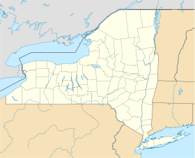
Oyster Bay ou plus exactement Town of Oyster Bay est une ville à l'est du comté de Nassau, sur Long Island aux États-Unis qui comptait 293 925 habitants lors du recensement de 2000.

Oyster Bay est également le nom d'un hameau faisant partie de la Town of Oyster Bay. C'est à proximité de ce hameau, dans le Village of Cove Neck, que se trouve la résidence d'été de Theodore Roosevelt, Sagamore Hill, qui est aujourd'hui un musée. Au moins six des 36 villages et hameaux de la Town of Oyster Bay, possèdent une grève donnant sur Oyster Bay Harbor. À une époque ou à une autre, chacun d'entre eux se vit nommé Oyster Bay.

Avec, Hempstead et North Hempstead, Oyster Bay est l'une des trois villes qui fut à l'origine de la création du comté de Nassau, lorsque celui-ci fut constitué à partir d'une portion orientale du comté de Queens.


Wikimedia Foundation. 2010.

Contenu soumis à la licence CC-BY-SA. Source : Article Oyster Bay (New York) de Wikipédia en français (auteurs)

Игры ⚽ Нужно решить контрольную?

Regardez d'autres dictionnaires:

  • Oyster Bay (New York) — Oyster Bay Theodore Roosevelts Sommerhaus Sagamore Hill Lage in New York …   Deutsch Wikipedia

  • Oyster Bay, New York — can refer to: Oyster Bay (town), New York Oyster Bay (hamlet), New York Oyster Bay (inlet), New York, also Oyster Bay Harbor, an inlet on the north shore of Long Island, New York South Oyster Bay, a lagoon off the southern shore of Long Island,… …   Wikipedia

  • Christ Church (Oyster Bay, New York) — Coordinates: 40°52′20.35″N 73°31′39.87″W / 40.8723194°N 73.5277417°W / 40.8723194; 73.5277417 …   Wikipedia

  • Council Rock (Oyster Bay, New York) — For other sites named Council Rock, see Council Rock. Coordinates: 40°52′20.21″N 73°31′53.83″W / 40.8722806°N 73.5316194°W / 40.8722 …   Wikipedia

  • U.S. Post Office (Oyster Bay, New York) — Infobox nrhp | name =US Post Office Oyster Bay nrhp type = caption = location= Oyster Bay, New York lat degrees = 40 lat minutes = 52 lat seconds = 27 lat direction = N long degrees = 73 long minutes = 32 long seconds = 0 long direction = W… …   Wikipedia

  • St. Dominic High School (Oyster Bay, New York) — Infobox School name = St. Dominic High School imagesize = caption = motto = established = 1928 closed = type = Private / co ed / Secondary affiliation = Roman Catholic district = grades = 9 12 president = principal = Mr. Robert Lowenberg head of… …   Wikipedia

  • Oyster Bay (Nueva York) — Oyster Bay Pueblo de los Estados Unidos Sagamore Hill …   Wikipedia Español

  • Oyster Bay (LIRR station) — Oyster Bay Oyster Bay s old LIRR station, currently being restored. Station statis …   Wikipedia

  • Oyster Bay Guardian — Oyster Bay Guardian …   Wikipedia

  • Oyster Bay Long Island Rail Road Turntable — Oyster Bay Railroad Museum U.S. National Register of Historic Places …   Wikipedia

Share the article and excerpts

Direct link
Do a right-click on the link above
and select “Copy Link”