Panamint Range

Panamint Range
Panamint Range
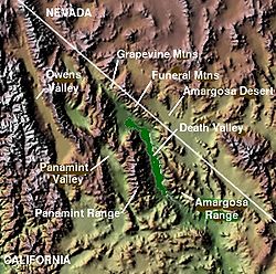
Carte topographique où figure la Panamint Range
Géographie
Altitude 3 369 m, Telescope Peak
Administration
Pays Drapeau des États-Unis États-Unis
État Californie
Comté Inyo

36°10′11″N 117°5′21″O / 36.16972, -117.08917

La Panamint Range est une petite chaîne de montagne située dans l'Est de la Californie, aux États-Unis. Elle se trouve plus précisément au nord du désert des Mojaves dans le comté d'Inyo. Elle délimite la Vallée de la mort située à l'est, et la Panamint Valley sur son flanc ouest. Son point culmunant est Telescope Peak, haut de 3 369 mètres d'altitude. La plus grande partie de la montagne est comprise dans le parc national de la Vallée de la mort. On peut voir depuis la Panamint Range le mont Whitney, qui est le sommet le plus haut de Californie. La chaîne appartient à la province géologique du Grand Bassin.

Panamint Range depuis le fond de la Panamint Valley.

Wikimedia Foundation. 2010.

Contenu soumis à la licence CC-BY-SA. Source : Article Panamint Range de Wikipédia en français (auteurs)

Игры ⚽ Поможем сделать НИР

Regardez d'autres dictionnaires:

  • Panamint Range — [pan′ə mint] 〚< name of a division of the Shoshonean Indians〛 mountain range in SE Calif., forming the W rim of Death Valley: highest peak, 11,045 ft (3,367 m) * * * ▪ mountains, United States       group of mountains lying mainly in Inyo county …   Universalium

  • Panamint Range — [pan′ə mint] [< name of a division of the Shoshonean Indians] mountain range in SE Calif., forming the W rim of Death Valley: highest peak, 11,045 ft (3,367 m) …   English World dictionary

  • Panamint Range — p1p5 Panamint Range Panamint Range von der Talsohle des Panamint Valley in südöstlicher Richtung Höchster Gipfel …   Deutsch Wikipedia

  • Panamint Range — The Panamint Range is a short rugged fault block mountain range on the northern edge of the Mojave Desert in eastern California in the western United States. The range runs north south for approximately 100 miles (160 km) through Inyo County,… …   Wikipedia

  • Panamint Range — Sp Pãnaminto kalnãgūbris Ap Panamint Range L JAV (Kalifornija) …   Pasaulio vietovardžiai. Internetinė duomenų bazė

  • Panamint Range — …   Useful english dictionary

  • Panamint City, California — Panamint City is a ghost town in the Panamint Range, near Death Valley, in California. It is also known by the official Board of Geographic Names identity, Panamint. [Panamint, California, 7.5 minute quadrangle, US Geological Survey, 1988 and… …   Wikipedia

  • Panamint Valley — is a long basin located east of the Argus Range and Slate Range, and west of the Panamint Range in eastern California, in the western United States. The northern end of the valley is in Death Valley National Park. The valley lies in a north south …   Wikipedia

  • Panamint Valley — est un bassin situé à l est de l Argus Range et de la Slate Range, et à l ouest de la Panamint Range, à l est de la Californie, ( …   Wikipédia en Français

  • Panamint Kangaroo Rat — Dipodomys panamintinus Panamint Kangaroo Rat Conservation status Least Concern (IUCN 3.1)[1] …   Wikipedia

Share the article and excerpts

Direct link
Do a right-click on the link above
and select “Copy Link”