Pontoon Dock (DLR)
- Pontoon Dock (DLR)
-
West Silvertown est une station du métro de Londres.
Voir aussi
Articles connexes
Wikimedia Foundation.
2010.
Contenu soumis à la licence CC-BY-SA. Source : Article Pontoon Dock (DLR) de Wikipédia en français (auteurs)
Regardez d'autres dictionnaires:
Pontoon Dock (DLR) — Station Pontoon Dock Pontoon Dock ist eine Station der Docklands Light Railway (DLR) im Londoner Stadtbezirk London Borough of Newham. Sie liegt in der Travelcard Tarifzone 3 an der North Woolwich Road im Stadtteil Silvertown. Die Station… … Deutsch Wikipedia
Pontoon Dock DLR station — Pontoon Dock is a station on the Docklands Light Railway which opened in December 2005. It is located on the King George V branch. Trains run Westbound to Bank in the City of London and Eastbound to King George V, passing through London City… … Wikipedia
King George V DLR station — London stations name = King George V caption = Station main entrance at the eastern end manager = Docklands Light Railway zone = 3 locale = North Woolwich borough = London Borough of Newham start=2 December 2005 platforms= 2 exits=King George V… … Wikipedia
London City Airport DLR station — London stations name = London City Airport caption = Station southern entrance and subway manager = Docklands Light Railway zone = 3 locale = London City Airport borough = London Borough of Newham start=2 December 2005 platforms= 2 exits= London… … Wikipedia
Mudchute DLR station — Mudchute … Wikipedia
Docklands Light Railway extension to Dagenham Dock — Coordinates: 51°30′32″N 0°04′18″E / 51.50889°N 0.07167°E / 51.50889; 0.07167 The D … Wikipedia
Custom House for Excel DLR station — Custom House for ExCeL … Wikipedia
Cyprus DLR station — Cyprus … Wikipedia
Cutty Sark for Maritime Greenwich DLR station — Cutty Sark for Maritime Greenwich Station entrance … Wikipedia
Crossharbour DLR station — Crossharbour … Wikipedia
 West Silvertown
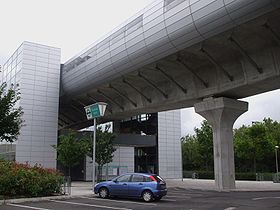
 DLR
DLR
