- Arrondissement de Saalfeld-Rudolstadt
-
Arrondissement de Saalfeld-Rudolstadt
Landkreis Saalfeld-Rudolstadt
Données générales Pays  Allemagne
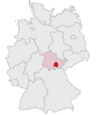
Land  Thuringe
District
(Regierungsbezirk)Chef-lieu Saalfeld Code arrondissemental
(Kreisschlüssel)16 0 73 Superficie 1 034,58 km² Population 118 303 hab. (31 décembre 2009) Densité 114 hab./km² Immatriculation SLF Communes 40 Villes principales Saalfeld, Rudolstadt Site web www.sa-ru.de Politique Préfet
(Landrat)Marion Philipp Partis au pouvoir SPD Localisation 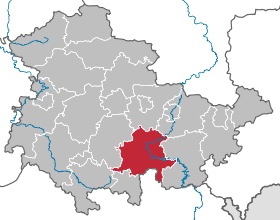
L'arrondissement de Saalfeld-Rudolstadt est un arrondissement (« Landkreis » en allemand) de Thuringe (Allemagne). Son chef-lieu est Saalfeld.Villes, communes & communautés d'administration
(nombre d'habitants en 2007) Villes
¹ commune membre d'une communauté d'administration
² remplit les fonctions administratives pour une autre commune- Bad Blankenburg (7281)
- Gräfenthal (2587)
- Königsee (5332)
- Lehesten ¹ (2003)
- Leutenberg (2464)
- Oberweißbach/Thür. Wald ¹ (1609)
- Remda-Teichel (3190)
- Rudolstadt (24.650)
- Saalfeld ² (27.488)
- Arnsgereuth (fonctions administratives remplies par la ville de Saalfeld/Saale) (259)
- Kamsdorf (2899)
- Kaulsdorf, (2893), remplit aussi les fonctions administratives pour :
- Altenbeuthen (239)
- Drognitz (703)
- Hohenwarte (141)
- Rottenbach (1928)
- Saalfelder Höhe (3412)
- Uhlstädt-Kirchhasel, (6590)
- Unterwellenborn (6540)
1. Bergbahnregion/Schwarzatal (6358)
- Cursdorf (723)
- Deesbach (457)
- Katzhütte (1897)
- Lichtenhain/Bergbahn (337)
- Meuselbach-Schwarzmühle (1335)
- Oberweißbach/Thür. Wald, ville (1609)
2. Lichtetal am Rennsteig (4502)
- Lichte * (1718)
- Piesau (839)
- Reichmannsdorf (837)
- Schmiedefeld (1108)
3. Vallée moyenne de la Schwarza (6550)
- Allendorf (391)
- Bechstedt (168)
- Döschnitz (301)
- Dröbischau (525)
- Mellenbach-Glasbach (1136)
- Meura (504)
- Oberhain (768)
- Rohrbach (212)
- Schwarzbourg (578)
- Sitzendorf (901)
- Unterweissbach (862)
- Wittgendorf (204)
4. Probstzella-Lehesten-Marktgölitz (5536)
- Lehesten, ville (2003)
- Probstzella (3533)
Catégorie :- Arrondissement de Thuringe


Wikimedia Foundation. 2010.