Province de Paktia
- Province de Paktia
-
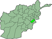
Paktiyâ

Districts de la province de Paktiya.
Paktiyâ est une province du sud-est de l'Afghanistan. Sa capitale est Gardêz.
Lien externe
Catégorie : Province d'Afghanistan
Wikimedia Foundation.
2010.
Contenu soumis à la licence CC-BY-SA. Source : Article Province de Paktia de Wikipédia en français (auteurs)
Regardez d'autres dictionnaires:
Paktia Province — Geobox|Province country = Afghanistan country name = Paktia native name = پکتیا map caption = Map of Afghanistan with Paktia highlighted capital = Gardez capital lat d = 33.6 capital long d = 69.5 population as of = 2002 population = 415,000… … Wikipedia
Paktia — Paktiyâ پکتیا (Paktiyâ) Administration Pays Afghanistan Type Province Capitale Gardêz … Wikipédia en Français
Orūzgān Province — Coordinates: 32°48′N 66°00′E / 32.8°N 66.0°E / 32.8; 66.0 … Wikipedia
Sar-e Pol Province — Coordinates: 35°36′N 66°18′E / 35.6°N 66.3°E / 35.6; 66.3 … Wikipedia
Wardak Province — Coordinates: 34°24′N 68°24′E / 34.4°N 68.4°E / 34.4; 68.4 … Wikipedia
Nangarhar Province — Coordinates: 34°15′N 70°30′E / 34.25°N 70.50°E / 34.25; 70.50 … Wikipedia
Nimruz Province — Coordinates: 31°00′N 62°30′E / 31.0°N 62.5°E / 31.0; 62.5 … Wikipedia
Nuristan Province — This page is about the province in Afghanistan. Nuristan is also a proposed name of Khyber Pakhtunkhwa Province of Pakistan. Coordinates: 35°15′N 70°45′E / 35.25°N 70.75°E … Wikipedia
Paktika Province — Geobox|Province country = Afghanistan country name = Paktika native name = پکتیکا map caption = Map of Afghanistan with Paktika highlighted capital = Sharan capital lat d = 32.5 capital long d = 68.8 population as of = 2002 population = 352,000… … Wikipedia
Logar Province — Geobox|Province country = Afghanistan country name = Logar native name = لوگر map caption = Map of Afghanistan with Logar highlighted capital = Pul i Alam capital lat d = 34.0 capital long d = 69.2 population as of = population = 292000… … Wikipedia