Ratoath
- Ratoath
-
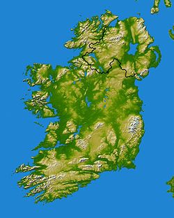
Ratoath (Ráth Tó en irlandais) est une ville du sud du comté de Meath en République d'Irlande, dont l'expansion est particulièrement rapide.
La ville de Ratoath compte 7 249 habitants au recensement de 2006), alors qu'elle n'était qu'un village de 1 061 habitants en 1996, soit un accroissement de 580% en 20ans.
C'est à proximité de Ratoath que se dispute l'Irish Grand National, une prestigieuse course hippique créée en 1870.
Voir aussi
Wikimedia Foundation.
2010.
Contenu soumis à la licence CC-BY-SA. Source : Article Ratoath de Wikipédia en français (auteurs)
Regardez d'autres dictionnaires:
Ratoath — (Irisch: Ráth Tó mit der Bedeutung Tós Fort)[1] ist eine Stadt mit 10.566 Einwohnern (2011) im Südosten des County Meath in Irland. Sie liegt an der Kreuzung der Regionalstraßen R155 und R125. Durch die Stadt fließt der Broad Meadow River (Irisch … Deutsch Wikipedia
Ratoath — Infobox Irish Place name = Ratoath gaeilge = Ráth Tó crest motto = map pin coords = left: 94px; top: 85px north coord = 53.507549 west coord = 6.462708 irish grid = O016519 area = elevation = province = Leinster county = County Meath town pop = 7 … Wikipedia
Ratoath — Original name in latin Ratoath Name in other language Rath To, Ratoath, Rth T State code IE Continent/City Europe/Dublin longitude 53.50806 latitude 6.4625 altitude 92 Population 4084 Date 2012 01 18 … Cities with a population over 1000 database
Ratoath (Parliament of Ireland constituency) — Parliament of Ireland former constituency infobox Name = Ratoath Manor Type = Manor Year = Post Union = DisenfranchisedRatoath was a constituency represented in the Irish House of Commons.Boundaries and Boundary ChangesThis constituency was the… … Wikipedia
Curraha — (Irish: Currach Átha, meaning the ford/crossing at the marshy/boggy area ) is a small village located 4.5 km from Ashbourne and 4 km from Ratoath, County Meath, Ireland. The area of Curraha stretches from the road towards Ratoath with… … Wikipedia
List of Acts of the Parliament of Ireland, 1701 to 1800 — NOTOC This is an incomplete list of Acts of the Parliament of Ireland for the years 1701 to 1800.Click here for the List of Acts of the Parliament of Ireland to 1700.The numbers after the titles of the acts are the chapter numbers. Acts are… … Wikipedia
Composite rules shinty-hurling — (Irish: Rialacha chomhréiteach sinteag iomáint), sometimes known simply as shinty hurling) is a hybrid sport which was developed to facilitate international matches between shinty players and hurling players. Shinty hurling is one of few team… … Wikipedia
Meath Echo — Type Newspaper Format Tabloid Owner Irish Village Papers Founded … Wikipedia
Meath Junior Football Championship — Founded 1897 Trophy Matthew Ginnity Cup Title holders Ballivor (1st title) Most titles Martry (6 titles) Sponsors Teach na Teamhrach The … Wikipedia
Meath Senior Football Championship 2010 — Meath S.F.C Season 2010 Champions Skryne 13th Senior Football Championship title Relegated St Ultans Winning Captain Aidan Tuite (Skryne) Leinster SCFC Skryne (semi finals) Rhode 2 11 Skryne 1 10 … Wikipedia


