Redcar et Cleveland
Contenu soumis à la licence CC-BY-SA. Source : Article Redcar et Cleveland de Wikipédia en français (auteurs)
Regardez d'autres dictionnaires:
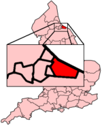
Redcar and Cleveland — Redcar et Cleveland Redcar et Cleveland en Angleterre Redcar et Cleveland est une autorité unitaire (Unitary authority) située au nord de l Angleterre, en le comté cérémonial de Yorkshire du Nord. Sa population est de 139 500 habitants … Wikipédia en Français
Redcar and Cleveland — Infobox UK district name = Borough of Redcar Cleveland status = Unitary, Borough region = North East England admincounty = North Yorkshire area = Ranked 174th 244.88 km² adminhq = Eston onscode = 00EE population = Ranked English district rank|ONS … Wikipedia
Redcar and Cleveland — Borough of Redcar and Cleveland Status Unitary Authority, Borough Region North East England Zerem. Grafschaft North Yorkshire … Deutsch Wikipedia
Redcar and Cleveland — ▪ unitary authority, England, United Kingdom formerly Langbaurgh on Tees unitary authority, geographic county of North Yorkshire, historic county of Yorkshire, England. It lies on the south side of the River Tees between Middlesbrough and … Universalium
Redcar and Cleveland — Sp Redkãras ir Klivlandas Ap Redcar and Cleveland L Anglijos unitarinė taryba, D. Britanija … Pasaulio vietovardžiai. Internetinė duomenų bazė
Normanby, Redcar and Cleveland — Coordinates: 54°33′25″N 1°09′25″W / 54.557°N 1.157°W / 54.557; 1.157 … Wikipedia
Wilton, Redcar and Cleveland — infobox UK place country = England latitude= 54.56981 longitude= 1.09673 official name= Wilton population = unitary england = Redcar and Cleveland region= North East England lieutenancy england = North Yorkshire constituency westminster= Redcar… … Wikipedia
Borough of Redcar and Cleveland — Admin ASC 2 Code Orig. name Borough of Redcar and Cleveland Country and Admin Code GB.ENG.K9 GB … World countries Adminstrative division ASC I-II
Cleveland Fire Brigade — area Coverage Area Boroughs of Hartlepool, Middlesbrough, Redcar and Cleveland Stockton on Tees … Wikipedia
Cleveland (England) — Cleveland als Grafschaft (1974 1996) Cleveland [ˈkliːvlənd] ist ein Gebiet im Nordosten Englands und war von 1974 bis 1996 eine Grafschaft. Der Name meint wörtlich cliff land und bezieht sich auf den hügeligen südlichen Teil von Cleveland mit… … Deutsch Wikipedia
 Royaume-Uni
 Town Hall