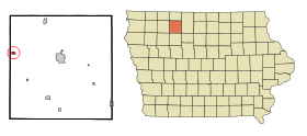
Ruthven (Iowa)
- Ruthven (Iowa)
-
Wikimedia Foundation.
2010.
Contenu soumis à la licence CC-BY-SA. Source : Article Ruthven (Iowa) de Wikipédia en français (auteurs)
Regardez d'autres dictionnaires:
Ruthven, Iowa — Infobox Settlement official name = Ruthven, Iowa settlement type = City nickname = motto = imagesize = image caption = image imagesize = image caption = image mapsize = 250x200px map caption = Location of Ruthven, Iowa mapsize1 = map caption1 =… … Wikipedia
Ruthven — may refer to:PlacesIn Scotland: *Ruthven, Aberdeenshire *Ruthven, Highland *Ruthven Barracks, Highland *Ruthven Castle, also known as Huntingtower Castle, north of Perth *Loch Ruthven, nature reserve to the south west of InvernessIn Australia: *… … Wikipedia
Ruthven — Ruthven, IA U.S. city in Iowa Population (2000): 711 Housing Units (2000): 350 Land area (2000): 0.421129 sq. miles (1.090719 sq. km) Water area (2000): 0.000000 sq. miles (0.000000 sq. km) Total area (2000): 0.421129 sq. miles (1.090719 sq. km)… … StarDict's U.S. Gazetteer Places
Ruthven, IA — U.S. city in Iowa Population (2000): 711 Housing Units (2000): 350 Land area (2000): 0.421129 sq. miles (1.090719 sq. km) Water area (2000): 0.000000 sq. miles (0.000000 sq. km) Total area (2000): 0.421129 sq. miles (1.090719 sq. km) FIPS code:… … StarDict's U.S. Gazetteer Places
Iowa highway jurisdictional transfer (2003) — Main article: List of Iowa state highways On July 1, 2003, the Iowa Department of Transportation transferred control of more than 600 miles (970 km) of highway to county and local governments in order to save money and to increase… … Wikipedia
List of high schools in Iowa — This is a list of high schools in the state of Iowa. You can also see a list of school districts in Iowa.Adair County*Nodaway Valley Community School District **Nodaway Valley High School, GreenfieldAdams County*Corning High School,… … Wikipedia
Alexander Grant Ruthven — Pour les articles homonymes, voir Ruthven. Alexander Grant Ruthven est un herpétologiste américain, né le 1er avril 1882 à Hull dans l Iowa et mort vers le 19 janvier 1971 à Ann Arbor. Il obtient son Bachelor of Sciences au Morningside… … Wikipédia en Français
Graettinger (Iowa) — Graettinger Administration Pays États Unis … Wikipédia en Français
Ayrshire (Iowa) — Ayrshire Administration Pays États Unis … Wikipédia en Français
Mallard (Iowa) — Mallard Administration Pays États Unis … Wikipédia en Français
 États-Unis
 Iowa
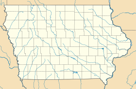
Iowa