Atauro
Contenu soumis à la licence CC-BY-SA. Source : Article Atauro de Wikipédia en français (auteurs)
Regardez d'autres dictionnaires:
Atauro — Saltar a navegación, búsqueda Atauro Estadísticas País … Wikipedia Español
Ataúro — Atauro Atauro Ataúro (pt) Atauro Géographie Pays … Wikipédia en Français
Atauro — Subdistrikt Atauro Hauptstadt Atauro Fläche 140,50 km²[1] Einwohnerzahl 8.602 (2010) … Deutsch Wikipedia
Ataúro — Subdistrikt Atauro Hauptstadt Atauro Einwohnerzahl (2004)[1] 7.863 Fläche 140 km²[2] … Deutsch Wikipedia
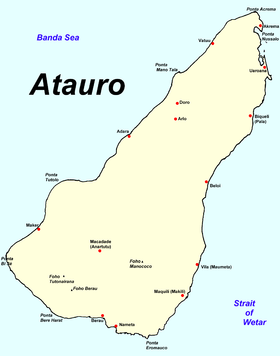
Atauro Island — (also Pulau Atauro, Ataúro) is a small island situated 25km north of Dili, East Timor, on the extinct Wetar segment of the volcanic Inner Banda Arc, between the Indonesian islands of Alor and Wetar. Politically it comprises one of the… … Wikipedia
Atauro (Schiff) — Atauro Albatroz Klasse Schiffstyp: Schnellboot Länge: 23,68 m Breite: 5,2 m … Deutsch Wikipedia
Atauro (P102) — Atauro Albatroz Klasse Schiffstyp: Schnellboot Länge: 23,68 m Breite: 5,2 m … Deutsch Wikipedia
Adara (Atauro) — Adara … Deutsch Wikipedia
East Timorese patrol boat Atauro — Career (Portugal, East Timor) East Timor Namesake: Atauro Island … Wikipedia
NRP Açor — Atauro Albatroz Klasse Schiffstyp: Schnellboot Länge: 23,68 m Breite: 5,2 m … Deutsch Wikipedia
 Timor oriental
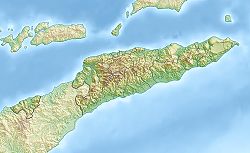
 Atauro
