Sayama
- Sayama
-
35°51′23″N 139°24′46″E / 35.85639, 139.41278
Sayama (狭山市, Sayama-shi?), anciennement Irumagawa, est une ville (市, shi) de la préfecture de Saitama, au Japon. La ville a été fondée le 1er juillet 1954. La population de la ville est de 155 027 habitants pour une superficie de 49,04 km2 (2010).
Sayama, ainsi que la ville voisine d'Iruma sont reconnues pour leur production de thé, qui est célèbre pour son goût.
La base aérienne d'Iruma des Forces d'auto-défense Japonaises se situe à Iruma et Sayama. Cette base fut connue sous le nom de Johnson Air Base sous le contrôle de l'US Air Force.
On y trouve l'un des huit points de vente du groupe Carrefour au Japon.
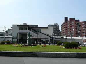
Comme pour de nombreuses villes au Japon, un plan d'urbanisme a conduit la destruction de la vielle ville au abords de la gare, les travaux devant se terminer en 2010.
Liens externes

Pont d'Hirose sur l'Iruma Gawa
Wikimedia Foundation.
2010.
Contenu soumis à la licence CC-BY-SA. Source : Article Sayama de Wikipédia en français (auteurs)
Regardez d'autres dictionnaires:
Sayama — shi 狭山市 Geographische Lage in Japan … Deutsch Wikipedia
sayama — (Ec.) f. Cierta *serpiente. * * * sayama. f. Ecuad. Especie de culebra … Enciclopedia Universal
sayama — f. Ecuad. Especie de culebra … Diccionario de la lengua española
Sayama — Original name in latin Sayama Name in other language Irumagawa, Sajama, Sayama, sayama si, xia shan shi, Саяма State code JP Continent/City Asia/Tokyo longitude 35.85295 latitude 139.41212 altitude 81 Population 160843 Date 2010 01 29 … Cities with a population over 1000 database
Sayama, Saitama — Japanese city Name = Sayama JapaneseName=狭山市 Prefecture=Saitama Region=Kantō Area km2=49.04 Population=160,917 PopDate=2003 Density km2=3281 Coords= LatitudeDegrees= 35 LatitudeMinutes= 51 LatitudeSeconds= LongtitudeDegrees= 139 LongtitudeMinutes … Wikipedia
Sayama Tea — is a type of green tea leaves produced mainly in the southwestern region of Saitama Prefecture and a small neighboring area in Northwestern Tokyo. In comparison to teas from other tea growing regions in Japan, Sayama Tea is characterized with its … Wikipedia
Sayama Incident — The nihongo|Sayama Incident|狭山事件 is a murder case named after Sayama City, Saitama Prefecure, Japan, where it took place. The incident, in which a man was imprisoned for 31 years, highlighted official discrimination against Japan s Burakumin or… … Wikipedia
Sayama Domain — The nihongo|Sayama Domain|狭山藩|Sayama han was a Japanese domain of the Edo period, located in Kawachi Province, and headquartered in what is now Sayama, Osaka. It was ruled for the entirety of its history by the Hōjō clan, a branch of the Late… … Wikipedia
Sayama-shi — Admin ASC 2 Code Orig. name Sayama shi Country and Admin Code JP.34.1852833 JP … World countries Adminstrative division ASC I-II
Sayama Station — is a train station in Osakasayama, Osaka Prefecture, Japan.Lines*Nankai Electric Railway **Kōya LineLayoutAdjacent stations###@@@KEYEND@@@### … Wikipedia

 Catégories :


