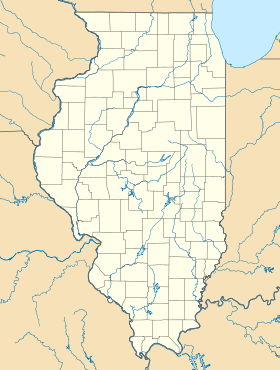
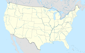
Schiller Park (Illinois)
Contenu soumis à la licence CC-BY-SA. Source : Article Schiller Park (Illinois) de Wikipédia en français (auteurs)
Regardez d'autres dictionnaires:
Schiller Park (Illinois) — Schiller Park Villa de los Estados Unidos … Wikipedia Español
Schiller Park, Illinois — Geobox|Settlement name = Schiller Park native name = other name = category = Village etymology = official name = motto = nickname = image caption = symbol = country = United States state = Illinois region = Cook region type = County district =… … Wikipedia
Schiller Park (Metra) — Infobox Station name=Schiller Park type=Metra commuter rail image size= image caption= address=4555 Ruby Street Schiller Park, Illinois coordinates= line=Rail color box|system=Metra|line=North Central other= structure= platform= depth= levels=… … Wikipedia
Schiller Park — Schiller Park, IL U.S. village in Illinois Population (2000): 11850 Housing Units (2000): 4335 Land area (2000): 2.766401 sq. miles (7.164946 sq. km) Water area (2000): 0.000000 sq. miles (0.000000 sq. km) Total area (2000): 2.766401 sq. miles (7 … StarDict's U.S. Gazetteer Places
Schiller Park, IL — U.S. village in Illinois Population (2000): 11850 Housing Units (2000): 4335 Land area (2000): 2.766401 sq. miles (7.164946 sq. km) Water area (2000): 0.000000 sq. miles (0.000000 sq. km) Total area (2000): 2.766401 sq. miles (7.164946 sq. km)… … StarDict's U.S. Gazetteer Places
Franklin Park, Illinois — Chicagoland municipality muni name = Franklin Park state = Illinois muni = Village date = 1892 county = Cook gov = Trustee village head label = President township = Leyden gov head = Daniel B. Pritchett pop = 19,800 density km = 1,610.2 density… … Wikipedia
Oak Park, Illinois — Coordinates: 41°53′N 87°48′W / 41.883°N 87.8°W / 41.883; 87.8 … Wikipedia
Deer Park, Illinois — For other cities in the U.S. by the same name, see Deer Park (disambiguation). Deer Park, Illinois Counties: Lake, Cook Township: Ela Incorporated: Village, 1957 President: Robert Kellermann ZIP code(s) … Wikipedia
Orland Park, Illinois — Counties: Cook, Will Township: Orland Incorporated: Village, 1892 Mayor: Daniel McLaughlin ZIP code(s): 60462, 60467 … Wikipedia
Oak Park (Illinois) — Oak Park Lake Street in Oak Park Lage in Illinois … Deutsch Wikipedia
 États-Unis
 Illinois