- Sokyriany
-
Sokyriany Сокиряни 

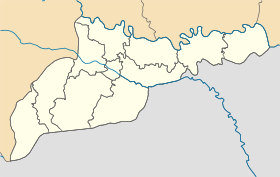
Géolocalisation sur la carte : Oblast de Tchernivtsi

Géolocalisation sur la carte : Ukraine
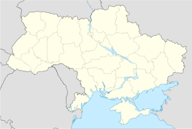
Coordonnées : Pays  Ukraine
Subdivision  Oblast de Tchernivtsi
Raïon Sokyriany Maire Vassyl Ravlyk Première mention 1666 Statut Ville depuis 1966 Population  9 538 hab. (2011)
Densité 3 179 hab./km² Superficie 3,0 km2 Indicatif tél. +380 3739 Code postal 60200 — 60007 Liste des villes d'Ukraine | Carte Sokyriany (en ukrainien : Сокиряни) ou Sokiriany (en russe : Сокиряны ; en roumain : Târgu Secureni) est une ville de l'oblast de Tchernivtsi, en Ukraine, et le centre administratif du raïon de Sokyriany. Sa population s'élevait à 9 538 habitants en 2011.
Sommaire
Géographie
Sokyriany est située à 111 km à l'est de Tchernivtsi et à 3 km de la frontière moldave.
Histoire
La plus ancienne mention écrite de Sokyriany date de 1666. Selon une légende, lorsqu'au début du XVIe siècle, les troupes turques envahirent la Moldavie et le Bucovine, les paysans, fuyant l'esclavage chez les Turcs, se réfugièrent dans les bois. Les fugitifs y choisirent un lieu, sur les rives d'un ruisseau qui se jetait dans le Dniestr. Les colons furent attirés par la forêt, impénétrable, abondante en champignons, en baies et en gibier, qui les protégeait des indésirables. Selon la légende, les gens vinrent dans la forêt avec des haches pour dégager une clairière pour bâtir des logements. Ils furent appelés « Sokyriany », puis la localité prit ce nom.
Population
Recensements (*) ou estimations de la population [1] :
Évolution démographique 1970* 1979* 1989* 2001* 2008 2009 2010 2011 10 913 10 648 11 819 10 258 9 629 9 622 9 606 9 538 Notes et références
- (ru) Recensements de 1970 et 1979 sur www.webgeo.ru — (en) World Gazetteer [1] — (uk) Office des statistiques d'Ukraine : Статистичний збірник «Чисельність наявного населення України на 1 січня 2008 року» [Manuel statistique « Nombre d'habitants de l'Ukraine au 1er janvier 2008 »]. [2] ; Статистичний збірник «Чисельність наявного населення України на 1 січня 2010 року» [Manuel statistique « Nombre d'habitants de l'Ukraine au 1er janvier 2010 »]. [3] ; Статистичний збірник «Чисельність наявного населення України на 1 січня 2011 року» [Manuel statistique « Nombre d'habitants de l'Ukraine au 1er janvier 2011 »]. [4]
Liens externes
- (uk) Informations officielles
- (uk) Portail de Sokyriany
- (ru) Cartes topographiques
- (ru) Carte routière
Catégories :- Ville d'Ukraine
- Ville de l'oblast de Tchernivtsi


Wikimedia Foundation. 2010.