Steenwijkerland

Steenwijkerland
Steenwijkerland
Blason de Steenwijkerland
Héraldique
Drapeau de Steenwijkerland
Drapeau

Administration
Pays Drapeau : Pays-Bas Pays-Bas
Province Overijssel
Code postal 7946, 8066, 8325-8349, 8355-8379
Géographie
Coordonnées 52° 46′ 59″ N 6° 07′ 01″ E / 52.783, 6.11752° 46′ 59″ Nord
       6° 07′ 01″ Est
/ 52.783, 6.117
  
Superficie 32 169 ha = 321,69 km2
  - Terre 29 112 ha = 291,12 km2
  - Eau 3 056 ha = 30,56 km2
Démographie
Population 43 255 hab.
Densité 148 hab./km2
Localisation
Localisation de Steenwijkerland

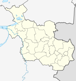
Géolocalisation sur la carte : Overijssel

(Voir situation sur carte : Overijssel)
Steenwijkerland

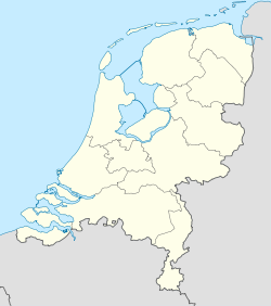
Géolocalisation sur la carte : Pays-Bas

(Voir situation sur carte : Pays-Bas)
Steenwijkerland

Steenwijkerland est une commune des Pays-Bas, en province d'Overijssel.

Villes et villages

Baarlo, Baars, Barsbeek, Basse, Belt-Schutsloot, Blankenham, Blauwe Hand, Blokzijl, De Bult, De Klosse, De Kolk, De Pol, Doosje, Dwarsgracht, Eesveen, Giethoorn, Heetveld, Kadoelen, Kalenberg, Kallenkote, Kuinre, Leeuwte, Marijenkampen, Moespot, Muggenbeet, Nederland, Oldemarkt, Onna, Ossenzijl, Paasloo, Roekebosch, Ronduite, Scheerwolde, Sint Jansklooster, Steenwijk, Steenwijkerwold, Tuk, Vollenhove, Wanneperveen, Wetering, Willemsoord, Witte Paarden, IJsselham et Zuidveen.

Lien externe

(de)(en)(fr)(nl) Site officiel


Wikimedia Foundation. 2010.

Contenu soumis à la licence CC-BY-SA. Source : Article Steenwijkerland de Wikipédia en français (auteurs)

Игры ⚽ Нужна курсовая?

Regardez d'autres dictionnaires:

  • Steenwijkerland — Gemeinde Steenwijkerland Flagge Wappen Provinz Overijssel …   Deutsch Wikipedia

  • Steenwijkerland — Infobox Settlement official name = Steenwijkerland mapsize = 280px subdivision type = Country subdivision name = Netherlands subdivision type1 = Province subdivision name1 = Overijssel area footnotes = (2006) area total km2 = 321.69 area land km2 …   Wikipedia

  • Baarlo (Steenwijkerland) — 52°44′16″N 5°57′0″E / 52.73778, 5.95 …   Wikipédia en Français

  • Tuk (Steenwijkerland) — Pour les articles homonymes, voir Tuk. 52°47′47″N 6°5′41″E / …   Wikipédia en Français

  • Baarlo (Steenwijkerland) — Baarlo is a small village in the Dutch province of Overijssel. It is located in the municipality Steenwijkerland, about 1 km northwest of the city of Blokzijl.Until the Noordoostpolder was reclaimed, the village lay on the dyke of the IJsselmeer …   Wikipedia

  • Gemeente Steenwijkerland — Admin ASC 2 Code Orig. name Gemeente Steenwijkerland Country and Admin Code NL.15.1708 NL …   World countries Adminstrative division ASC I-II

  • Steenwijk — Gemeinde Steenwijkerland Flagge Wappen Provinz …   Deutsch Wikipedia

  • Steenwijk — Pour les articles homonymes, voir Steenwyck. Steenwijk Administration Pays …   Wikipédia en Français

  • Hasselt (Niederlande) — Gemeinde Zwartewaterland Flagge Wappen Provinz …   Deutsch Wikipedia

  • Kuinre — 52°47′11″N 5°50′36″E / 52.78639, 5.84333 …   Wikipédia en Français

Share the article and excerpts

Direct link
Do a right-click on the link above
and select “Copy Link”