Tata Sabaya

Tata Sabaya
Tata Sabaya
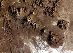
Vue satellite du Tata Sabaya (au nord des hummocks)
Géographie
Altitude 5 430 m
Massif Cordillère Occidentale (Andes)
Coordonnées 19° 07′ 57″ Sud
       68° 31′ 30″ Ouest
/ -19.1325, -68.525
19° 07′ 57″ S 68° 31′ 30″ W / -19.1325, -68.525
Administration
Pays Drapeau de Bolivie Bolivie
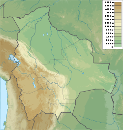
Département Oruro
Province Atahuallpa
Géologie
Roches Andésite
Type Volcan gris
Activité Inconnue
Dernière éruption Inconnue
Code [1] 1505-032
Observatoire Aucun

Géolocalisation sur la carte : Bolivie

(Voir situation sur carte : Bolivie)
Tata Sabaya

Le Tata Sabaya est un stratovolcan, en Bolivie. Il est situé au nord du Salar de Coipasa, dans l'Altiplano. La date de sa dernière éruption est inconnue, mais elle se situe vers l'Holocene étant donné l'apparence de la montagne. Tata Sabaya est composé de trois éléments distincts. À sa base on trouve un bouclier pyroclastique, surmonté d'un dôme de lave, et finalement par un stratovolcan. Un des évênements les plus spéctaculaires du passé récent du volcan fut l'avalanche de poussière qui couvrit 300 km2 au sud de la montagne. Des éruptions postérieurs ont redonné au volcan sa forme actuelle. Des coulées de lave récentes se trouvent sur ses flancs ouest et nord-ouest, et un écroulement partiel du dôme sommital a produit des dépôts sur le flanc sud-ouest.

Lien externe

Sur les autres projets Wikimedia :


Wikimedia Foundation. 2010.

Contenu soumis à la licence CC-BY-SA. Source : Article Tata Sabaya de Wikipédia en français (auteurs)

Игры ⚽ Нужно решить контрольную?

Regardez d'autres dictionnaires:

  • Tata Sabaya — Infobox Mountain Name = Tata Sabaya Photo= Cabaray.jpg Caption = Debris avalanche hummocks in the bottom of this image reveal the location of the volcano. Elevation =5,430 metres (17,815 ft) Location =Bolivia Range =Andes Prominence = Coordinates …   Wikipedia

  • Sabaya — Basisdaten Einwohner (Stand) 703 Einw. (Fortschreibung 2010) [1] Höhe 3.707 m Telefonvo …   Deutsch Wikipedia

  • Sabaya — is a small town in the Bolivian Oruro Department.Sabaya is the administrative center of Atahuallpa Province and Sabaya Municipio alike and is located 200 km southwest of the department capital Oruro. It is situated at 3,698 m above sea level in… …   Wikipedia

  • Cahuana (Kanton) — Kanton Cahuana Basisdaten Einwohner (Stand) 208 Einw. (2001)[1] Telefonvorwahl (+591) Höhe 3.800  …   Deutsch Wikipedia

  • Cahuana — Basisdaten Einwohner (Stand) 85 Einw. (Volkszählung 2001) [1] Höhe 3.761 m Telefonvorw …   Deutsch Wikipedia

  • Pagador (Kanton) — Kanton Pagador Basisdaten Einwohner (Stand)  Bevölkerungsdichte 134 Einw. (2001)[1] 1 Einw./km² Fläche 230 km² Höhe …   Deutsch Wikipedia

  • Villa Vitalina (Kanton) — Kanton Villa Vitalina Basisdaten Einwohner (Stand)  Bevölkerungsdichte 319 Einw. (2001)[1] 1 Einw./km² Telefonvorwahl (+591) Fläche 360 km² …   Deutsch Wikipedia

  • Тата-Сабая — исп. Tata Sabaya …   Википедия

  • List of Bolivia-related topics — This is a list of topics related to Bolivia. Those interested in the subject can monitor changes to the pages by clicking on Related changes in the sidebar.Bolivia* Bolivia * Cocalero * Environmental issues in Bolivia * Foreign aid to Bolivia *… …   Wikipedia

  • Liste des volcans de Bolivie — Cet article recense les volcans de Bolivie. Sommaire 1 Liste 2 Annexes 2.1 Liens internes 2.2 Liens externes …   Wikipédia en Français

Share the article and excerpts

Direct link
Do a right-click on the link above
and select “Copy Link”