Tekezé
- Tekezé
-
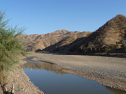
Le Tekezé est un sous-affluent du Nil. Il prend sa source en Éthiopie et se jette dans l'Atbara au Soudan.
Le cours de la rivière Tekezé mesure 608 km et est plus long que celui de l'Atbara à leur point de confluence. La rivière a creusé un profond canyon, le plus profond d'Afrique et l'un des plus profonds au monde. En certains endroits sa profondeur atteint 2000 mètres.
La rivière prend sa source dans les montagnes du centre de l'Éthiopie non loin du mont Qachen. Il prend une direction ouest, puis nord et à nouveau ouest, formant la partie la plus occidentale de la frontière entre l'Éthiopie et l'Érythrée. La rivière poursuit son cours dans la partie sud-est du Soudan avant de rejoindre l'Atbara par 14°10′N 36°00′E / 14.167, 36.
La Chine a construit le barrage de Tekeze, 180 m de haut, « plus grand projet de coopération dans un pays africain » selon la presse chinoise, surnommé le « barrage des Trois Gorges éthiopien » par Sinohydro, l'entreprise chinoise qui a remporté le chantier.
Articles connexes
Notes et références
Wikimedia Foundation.
2010.
Contenu soumis à la licence CC-BY-SA. Source : Article Tekezé de Wikipédia en français (auteurs)
Regardez d'autres dictionnaires:
Tekeze — Vorlage:Infobox Fluss/BILD fehltVorlage:Infobox Fluss/DGWK fehltVorlage:Infobox Fluss/QUELLE fehltVorlage:Infobox Fluss/QUELLHÖHE fehltKoordinaten fehlen! Hilf mit.Vorlage:Infobox Fluss/MÜNDUNGSHÖHE fehltVorlage:Infobox Fluss/HÖHENUNTERSCHIED… … Deutsch Wikipedia
Tekeze-Talsperre — Bild gesucht BW … Deutsch Wikipedia
Tekeze-Setit — TekezeVorlage:Infobox Fluss/KARTE fehlt DatenVorlage:Infobox Fluss/GKZ fehlt … Deutsch Wikipedia
Tekezé River — The Tekezé River is a major river of Ethiopia, and forms a section the westernmost border of Ethiopia and Eritrea for part of its course. The river is also known as the Setit in Eritrea, western Ethiopia, and eastern Sudan. According to the… … Wikipedia
Río Tekezé — Saltar a navegación, búsqueda Río Tekezé (Tekezé Setit) Vista del río País que atraviesa … Wikipedia Español
Setit — Vorlage:Infobox Fluss/BILD fehltVorlage:Infobox Fluss/DGWK fehltVorlage:Infobox Fluss/QUELLE fehltVorlage:Infobox Fluss/QUELLHÖHE fehltKoordinaten fehlen! Hilf mit.Vorlage:Infobox Fluss/MÜNDUNGSHÖHE fehltVorlage:Infobox Fluss/HÖHENUNTERSCHIED… … Deutsch Wikipedia
Geography of Ethiopia — Map of Ethiopia. Satellite image of Ethiopi … Wikipedia
Holland ABAY Executive — Die Pkw Modelle ABAY Executive, Awash Executive und Tekeze sind Produkte des äthiopischen Automobilherstellers Holland Car. Alle drei Fahrzeuge entstanden in dem Joint Venture mit Lifan und sind zueinander Schwestermodelle. Wobei der Tekeze den… … Deutsch Wikipedia
Dams and hydropower in Ethiopia — Contents 1 List of dams and hydropower plants 2 Financial costs 3 Delays and technical challenges … Wikipedia
Atbarah River — Mouth 17°40′41″N 33°58′25″E / … Wikipedia
 Éthiopie
 Érythrée
 Soudan