- Triple Divide Peak
-
Triple Divide Peak 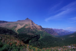
Vue du Triple Divide Peak.Géographie Altitude 2 444 m Massif Chaînon Lewis (montagnes Rocheuses) Coordonnées Administration Pays  États-Unis
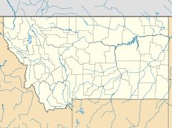
État Montana Comtés Flathead, Glacier Géolocalisation sur la carte : Montana

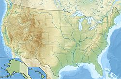
Géolocalisation sur la carte : États-Unis
modifier 
Le Triple Divide Peak (2 444 m) est une montagne située dans le parc national de Glacier dans l'État du Montana aux États-Unis. Son sommet est le point de jonction entre les bassins hydrographiques nord-américains de l'océan Pacifique, de l'océan Atlantique et de l'océan Arctique. Les eaux s'écoulant sur ses versants nord et nord-est se dirigent vers l'océan Arctique, les eaux qui s'écoulent du nord-ouest au sud se dirigent vers l'océan Pacifique tandis que les eaux qui se déversent au sud-est partent vers le golfe du Mexique.
Sommaire
Annexes
Articles connexes
- Parc national de Glacier
- Triple Divide Peak (Tulare) (3 850 m, Californie)
- Triple Divide Peak (Madera) (3 535 m, Californie)
Liens externes
- (en)USGS Mount Stimson Quad, Topozone. Consulté le 09-03-2008
- (en)Triple Divide Peak, Montana, Peakbagger. Consulté le 09-03-2008
- (en)Triple Divide Peak - Climbing, Hiking & Mountaineering, Summitpost. Consulté le 09-03-2008
Notes et références
Catégories :- Sommet des Rocheuses
- Sommet des États-Unis
- Montagne du Montana
- Comté de Flathead
- Comté de Glacier
- Parc national de Glacier
- Ligne de partage des eaux entre océan Atlantique et océan Pacifique
- Ligne de partage des eaux entre océan Arctique et océan Atlantique


Wikimedia Foundation. 2010.