Velddriel
Contenu soumis à la licence CC-BY-SA. Source : Article Velddriel de Wikipédia en français (auteurs)
Regardez d'autres dictionnaires:
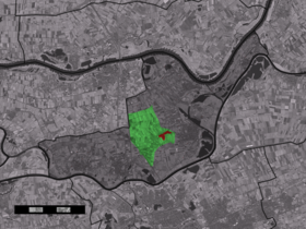
Velddriel — Dutch town locator maps mun town caption = The town centre (red) and the statistical district (light green) of Velddriel in the municipality of Maasdriel.Velddriel (coord|51|46|N|5|18|E|type:city(573)) is a town in the Dutch province of… … Wikipedia
Maasdriel — Gemeinde Maasdriel Flagge Wappen Provinz … Deutsch Wikipedia
Maasdriel — Héraldique … Wikipédia en Français
Maasdriel — Infobox Settlement official name = Maasdriel mapsize = 280px subdivision type = Country subdivision name = Netherlands subdivision type1 = Province subdivision name1 = Gelderland area footnotes = (2006) area total km2 = 75.49 area land km2 =… … Wikipedia
List of places in the Netherlands — This is an alphabetical list of places (cities, towns, villages) in the Netherlands. Lists per province can be found at:* List of towns in Groningen * List of towns in Friesland * List of towns in Drente * List of towns in Overijssel * List of… … Wikipedia
Rob Harmeling — Infobox Cyclist ridername = Rob Harmeling fullname = Rob Harmeling nickname = dateofbirth = birth date and age|1964|12|4 country = NED height = weight = currentteam = Retired discipline = Road role = Rider ridertype = amateurteams = amateuryears … Wikipedia
Alem — 51° 47′ 13″ N 5° 20′ 37″ E / 51.7869, 5.34361 … Wikipédia en Français
Ammerzoden — 51° 45′ 00″ N 5° 13′ 00″ E / 51.75, 5.21666667 … Wikipédia en Français
Autoroute néerlandaise A2 — Pour les articles homonymes, voir Autoroute A2. Rijksweg 2 Longueur : 211 km … Wikipédia en Français
Bommelerwaard — Situation du Bommelerwaard Le Bommelerwaard est une région naturelle des Pays Bas, située dans le sud ouest de la province du Gueldre. La région a une superficie d environ 147,6 km² et compte environ 48 000 habitants (1999). La circonférence … Wikipédia en Français
 Pays-Bas