Via Amerina

Via Amerina
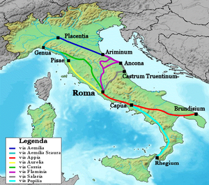
Itinéraire de la Via Cassia (en vert).

La Via Amerina était une route qui débutait au nord, à la sortie de la Via Cassia près de Baccanae (Statio ad Vacanas), traversait l' Ombrie en desservant les villes de Faleries, Tuder et Pérouse et finit par rejoindre à nouveau la Via Cassia à Clusium.

Sommaire

Histoire

La Via Amerina doit probablement son nom au légendaire roi ombrien Ameroe auquel la ville d'Amelia (Ameria) doit son nom. La route a été tracée entre -220 et 219 av.J.-C. par le censeur Caius Flaminius, un des principaux artisans de l'expansion romaine vers la vallée padane en réutilisant des parcours plus anciens découlant des formes de peuplement éparpillé umbro-italique.


Lors des incursions du lombard Faroald duc de Spolète, qui coupèrent la Via Flaminia, voie de communication vitale entre Rome et Ravenne, la Via Amerina fut améliorée et fortifiée constituant l'unique liaison entre Rome et l' Empire d'Orient traversant le couloir bysantin. Ces œuvres figurent parmi les derniers travaux routiers réalisés en Italie dans l'Antiquité tardive.

Devenue la nouvelle route militaire et stratégique, la Via Amerina « est devenue le noyau de communications de l'Italie impériale et la preuve que l'impériale Italie existait encore. » [1]

La Table de Peutinger, un itinéraire pictural d'époque médiévale réalisée à partir de documents du Bas Empire romain, énumère tout au long de la Via Amerina les cités de Nepe, Faleros, Castellum Amerinum, Ameria, Tuder, Vettona, Pirusio et Clusio (Chiusi) où la route rejoignait la via Cassia.

La dernière nouvelle concernant l'utilisation effective de la via Amerina remonte à l'an 1497, quand César Borgia décréta sa fin en ordonnant la destruction du pont sur le Tibre près de Orte.

Sources

  • Voir lien externe

Notes et références

  1. Janvier T. Hallenbeck, Pavie et Rome : La monarchie lombarde et de la papauté dans le huitième siècle Transactions of the American Philosophical Society New Series 72.4 (1982 p.  1-186) p. 8.

Voir aussi

Liens externes


Wikimedia Foundation. 2010.

Contenu soumis à la licence CC-BY-SA. Source : Article Via Amerina de Wikipédia en français (auteurs)

Игры ⚽ Поможем написать реферат

Regardez d'autres dictionnaires:

  • Vía Amerina — La Vía Amerina fue una vía o camino empedrado romano nombrado en tiempos de Adriano que iba de Roma a Ameria. En realidad salía de la Vía Cassia en Baccanae (Baccano) e iba por Nepete y Falerii hasta Ameria. Itinerario de la Vía Amerina Sus… …   Wikipedia Español

  • Via Salaria — отмечена серым цветом Соляная дорога (лат. Via Salaria)  древний торговый путь, по которому проходила транспортировка соли, что также отражено в названии дороги. Соляная дорога обеспечивала Риму монополию на соль и стала одним из источников… …   Википедия

  • Via Militaris — на карте античной Греции Via Militaris (также известна под названием Via Diagonalis)  римская дорога, построенная при императоре Не …   Википедия

  • Via Cassia — The Via Cassia was an important Roman road striking out of the Via Flaminia near the Milvian Bridge in the immediate vicinity of Rome and, passing not far from Veii traversed Etruria. The Via Cassia passed through Baccanae, Sutrium, Vulsinii,… …   Wikipedia

  • Via Domitia — Route of the Via Domitia …   Wikipedia

  • Via Ostiensis — The Via Ostiensis (Italian: via Ostiense) was an important road in ancient Rome. It ran west 30 km from the city of Rome to its important sea port of Ostia Antica, from which it took its name. The road began near the Forum Boarium, ran… …   Wikipedia

  • Via Appia — Вид на Аппиеву дорогу Аппиева дорога (лат. Via Appia)  самая значимая из античных общественных дорог Рима. Дорога, проложенная в 312 году до н. э. при цензоре Аппии Клавдии Цеке, проходила из Рима в Капую, позднее была проведена до Брундизия.… …   Википедия

  • Via Aemilia Scauri — Дорога Эмилия Скавра обозначена голубым цветом Дорога Эмилия Скавра (лат. Via Aemilia Scauri)  римская дорога, построенная в 109 году до н. э. цензором Марком Эмилием Скавром. Дорога шла вдоль лигурийского побережья и соединяла между собой… …   Википедия

  • Via Aemilia — Эмилиева дорога обозначена синим цветом Эмилиева дорога (лат. Via Æmilia)  римская дорога, построенная в 187 году до н. э. консулом Марком Эмилием Лепидом. Дорога соединяет Пьяченцу и Римини и проходит через многие города, расположенные в… …   Википедия

  • Via Aurelia — Аврелиева дорога обозначена желтым цветом Аврелиева дорога (лат. Via Aurelia)  римская дорога, проходившая по средиземноморскому побережью Италии и древней Галлии. Строительство дороги началось в 241 г. до н. э. по инициативе римского консула Гая …   Википедия

Share the article and excerpts

Direct link
Do a right-click on the link above
and select “Copy Link”