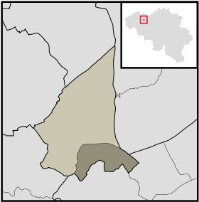
Vinderhoute
- Vinderhoute
-
Catégorie :
- Commune avant fusion de l'arrondissement de Gand
Wikimedia Foundation.
2010.
Contenu soumis à la licence CC-BY-SA. Source : Article Vinderhoute de Wikipédia en français (auteurs)
Regardez d'autres dictionnaires:
Lovendegem — Infobox Belgium Municipality name=Lovendegem picture= picture map arms= region=BE REG FLE community=BE NL province=BE PROV OV arrondissement=Ghent nis=44036 pyramid date= 0 19= 20 64= 65= foreigners= foreigners date= mayor=Christiaan De… … Wikipedia
Lovendegem — Lovendegem … Deutsch Wikipedia
Canal de la Lieve — Lieve La Lieve à Gand, à la hauteur du Château des Comtes (vue plongeante prise du haut du donjon) … Wikipédia en Français
Lieve — La Lieve à Gand, à la hauteur du Château des Comtes (vue plongeante prise du haut du donjon) … Wikipédia en Français
List of postal codes in Belgium — Belgian postal codes are numeric and consist of 4 numbers, although the last one is often zero. The first digit indicates the province (except for the 3xxx numbers that are shared by the eastern part of Flemish Brabant and Limburg and the and… … Wikipedia
Luchteren — is the most rural parish of Drongen, which is itself a sub municipality of Ghent, East Flanders, Flanders, Belgium.Most shops and other important features are located in the main streets Beekstraat, Antoon Catriestraat, Boskeetstraat and… … Wikipedia
Drongen — Lage von Drongen in Gent Ansicht von Drongen mit alter Abtei, St. Gerolfskirc … Deutsch Wikipedia
Gent — Gent … Deutsch Wikipedia
Arrondissement Administratif De Gand — Arrondissement de Gand Géographie … Wikipédia en Français
Arrondissement administratif de Gand — 51° 03′ N 3° 42′ E / 51.05, 3.7 … Wikipédia en Français

 Belgique
 Région flamande
 Province de Flandre-Orientale