Vucetici
- Vucetici
-
Vučetići
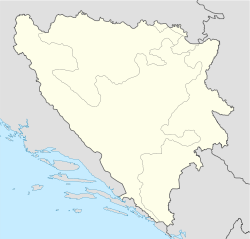
Vučetići (en serbe cyrillique : Вучетићи) est un village de Bosnie-Herzégovine. Il est situé dans la municipalité de Goražde et dans le canton du Podrinje bosnien, Fédération de Bosnie-et-Herzégovine. Au recensement de 1991, il comptait 87 habitants, dont une majorité de Serbes[1].
Démographie
Répartition de la population (1991)
| Nationalité |
Nombre |
% |
| Serbes |
86 |
98,85 |
| Inconnus/Autres |
1 |
1,15[1] |
Notes et références
- ↑ a et b (bs)(hr)(sr) Livre : Composition nationale de la population - Résultats de la République par municipalités et localités 1991, Bulletin statistique n°234, Publication de l'Institut national de statistique de Bosnie-Herzégovine, Sarajevo.
Voir aussi
Articles connexes
Liens externes
 Portail de la Bosnie-Herzégovine
 Serbie et peuple serbe
Catégories : Localité de la Fédération de Bosnie-et-Herzégovine | Localité de Bosnie-Herzégovine à majorité serbe
Wikimedia Foundation.
2010.
Contenu soumis à la licence CC-BY-SA. Source : Article Vucetici de Wikipédia en français (auteurs)
Regardez d'autres dictionnaires:
Vučetići — 43° 40′ 49″ N 18° 56′ 30″ E / 43.6803, 18.9417 … Wikipédia en Français
Gorazde (Bosnie-Herzegovine) — Goražde (Bosnie Herzégovine) Pour les articles homonymes, voir Goražde. Goražde Горажде [[Image:|100px|center|Blason]] [[Image:|100px|center|Drapeau]] … Wikipédia en Français
Goražde (Bosnie-Herzégovine) — Pour les articles homonymes, voir Goražde. 43° 40′ 01″ N 18° 58′ 35″ E … Wikipédia en Français
Kuči — is one of the Serb Highland clans in Montenegro, and is also a name of geographical region in eastern Montenegro which the clan populates. The region is located north east of Podgorica, and extends along the border with Albania, thus one reason… … Wikipedia
List of settlements in Bosnia and Herzegovina — This is a complete list of settlements in Bosnia and Herzegovina, as recorded by 1991 census, sorted by municipalities. Town of Sarajevo = Sarajevo Centar = • Mrkovići • Nahorevo• Poljine• Radava• Sarajevo (part of settlement)• Vića Sarajevo… … Wikipedia
List of settlements in the Federation of Bosnia and Herzegovina/V — Va Vašarovići Ve Vedro Polje, Velika Kladuša, Veliki Ograđenik, Veluša, Velja Međa (municipality Ravno), Veljaci, Vesela Vi Vihovići (municipality Mostar), Vileši, Vinište, Vinjani, Vionica, Vir, Visoko, Vitez, Vitina, Vitkovići, Višići Vl Vinine … Wikipedia
Brevier von Dabar — ist ein aus dem Jahre 1486 stammendes Stundengebetsbuch, welches in glagolitisch kroatischer Handschrift verfasst ist. Mit Erlaubnis des Papstes Innozenz IV. durften ab 1248 die Kirchen im Nordwesten Kroatiens als einzige innerhalb der… … Deutsch Wikipedia
Dabar — Dabar … Deutsch Wikipedia
Ahmovici — Ahmovići Ahmovići Ахмовићи [[Image:|100px|center|Blason]] [[Image:|100px|center|Drapeau]] Blason Drapeau … Wikipédia en Français
Ahmovići — 43° 37′ 31″ N 18° 56′ 32″ E / 43.6253, 18.9422 … Wikipédia en Français

 Bosnie-Herzégovine