- Bad Aibling
-
Bad Aibling 

Administration Toponyme officiel Pays  Allemagne
Land Bavière District
(Regierungsbezirk)Haute-Bavière Arrondissement
(Landkreis)Rosenheim Code communal
(Gemeindeschlüssel)09 1 87 117 Code postal 83035-83043 Indicatif téléphonique 08061 Immatriculation RO Site web www.aibling.de Politique Bourgmestre
(Bürgermeister)Felix Schwaller (CSU) Partis au pouvoir Géographie Coordonnées Altitude (NN) 498 m Superficie 41,55 km2 Démographie Population 17 718 hab. (30 juin 2005) Densité 430 hab./km2 modifier 
Bad Aibling est une ville de Bavière, en Allemagne. La rivière Mangfall la traverse et c'est le lieu d'un important spa de santé (bains de boue).
Elle compte 18 000 habitants, se trouve 498 mètres au-dessus du niveau de la mer et s'étend sur 41,55 km².
Sommaire
Histoire
La première mention historique de Bad Albling est faite en 804.
Après la Seconde Guerre mondiale, la ville a évolué comme un centre majeur pour les services de renseignements et les services secrets. En 2004, la station Echelon a fermé [réf. nécessaire] après des décennies d'opération.
Galerie d'images
-
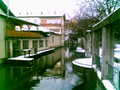
"Klein Venedig" (Petite Venise)
-

Glonn
-

Inner Rosenheimer Straße
-

Kirchzeile avec Hofberg
-

Cimetière central de type italien
Jumelage
La ville de Bad Aibling est jumelée avec :
 Cavaion Veronese (Italie) depuis 2006
Lien externe
Catégories :- Ville de Bavière
- Station thermale allemande
-


Wikimedia Foundation. 2010.