1500 Louisiana Street
- 1500 Louisiana Street
-
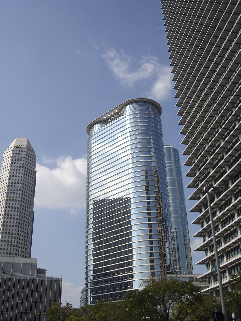
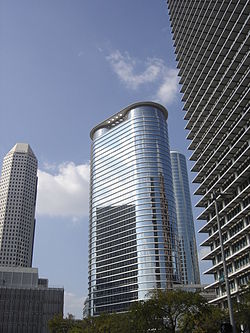
Le 1500 Louisiana Street est un gratte-ciel de bureaux de 183 mètres de hauteur, construit à Houston au Texas de 1999 à 2002. L'immeuble a été construit pour la société Enron mais cette entreprise n'a jamais occupé le bâtiment suite à un énorme scandale. L'immeuble a été acheté en mars 2004 par la société Chevron-Texaco pour 230 millions de $.
L'architecte de l'immeuble est Cesar Pelli.
Articles connexes
Liens externes
Catégories :
- Gratte-ciel de Houston
- Gratte-ciel mesurant entre 150 et 199 mètres
- Gratte-ciel construit en 2002
Wikimedia Foundation.
2010.
Contenu soumis à la licence CC-BY-SA. Source : Article 1500 Louisiana Street de Wikipédia en français (auteurs)
Regardez d'autres dictionnaires:
1500 Louisiana Street — Infobox Skyscraper building name = 1500 Louisiana Street caption = year highest = year end = plural = location = 1500 Louisiana Street, Houston, Texas coordinates = status = groundbreaking = constructed = 1999 2002 est completion = opening =… … Wikipedia
Louisiana Superdome — Infobox Stadium stadium name = Louisiana Superdome nickname = The Dome, Superdome, New Orleans Superdome location = 1500 Poydras Street New Orleans, Louisiana 70112 broke ground = August 11, 1971 opened = August 3, 1975 reopened = September 25,… … Wikipedia
Louisiana — This article is about the U.S. state of Louisiana. For other uses, see Louisiana (disambiguation). State of Louisiana État de Louisiane Léta de la Lwizyàn … Wikipedia
National Register of Historic Places listings in Louisiana — Map of Louisiana s 64 parishes … Wikipedia
National Register of Historic Places listings in Orleans Parish, Louisiana — Location of Orleans Parish in Louisiana This is a list of the National Register of Historic Places listings in Orleans Parish, Louisiana. This is intended to be a complete list of the properties and districts on the National Register of Historic… … Wikipedia
National Register of Historic Places listings in East Baton Rouge Parish, Louisiana — Location of East Baton Rouge Parish in Louisiana This is a list of the National Register of Historic Places listings in East Baton Rouge Parish, Louisiana. This is intended to be a complete list of the properties and districts on the National… … Wikipedia
St. Bernard Parish, Louisiana — Infobox U.S. County county = Saint Bernard Parish state = Louisiana founded year = 1807 founded date = seat wl = Chalmette largest city wl = Chalmette area total sq mi = 4606 area total km2 = 11929 area land sq mi = 1204 area land km2 = 3118 area … Wikipedia
Main Street Station (Richmond) — For the Amtrak station also in Richmond serving the Silver Meteor and Silver Star service, see Richmond Staples Mill Road (Amtrak station). Richmond Main Street Station Richmond Main Street … Wikipedia
Список самых высоких зданий Хьюстона — содержит упорядоченные по высоте высотные здания американского города Хьюстон, штат Техас. Высочайшее здание в Хьюстоне 75 этажная JPMorgan Chase Tower высотой 305 метров, построенная в 1982 году[1]. Башня JPMorgan Chase является самым… … Википедия
Список самых высоких зданий Техаса — ранжирует по высоте высотные здания штата Техас, США. Самое высокое здание Техаса 75 этажная башня JPMorgan Chase высотой 305 метров, построенная в 1982 году, находящаяся в Хьюстоне[1][2]. Второе и третье по высоте здания 71 этажный… … Википедия
 États-Unis