District d'Âlwâr

District d'Âlwâr

27° 34′ N 76° 36′ E / 27.57, 76.6

Page d'aide sur l'homonymie Ne doit pas être confondu avec Halwar.
District d'Âlwâr
Rajastan Alwar district.png
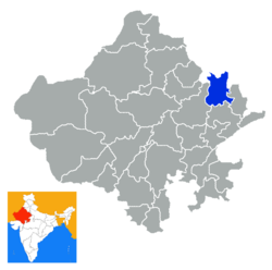
Le numéro 29 sur la carte
Administration
Pays Drapeau d'Inde Inde
Type District
État Rajasthan
Siège administratif Alwar
Géographie
Superficie 8 380 km2
Population
Population 2 990 862 hab. (2001)
Densité 356,9 hab./km2

L'Âlwâr devenu district d'Âlwâr était un état princier de l'Inde durant la période du Raj britannique. Il fait depuis partie intégrante de l'État du Rajasthan.

Sommaire

Histoire de la principauté
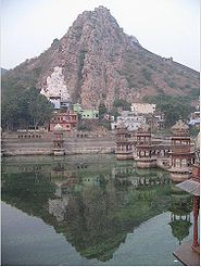
Vue d'Âlwâr.

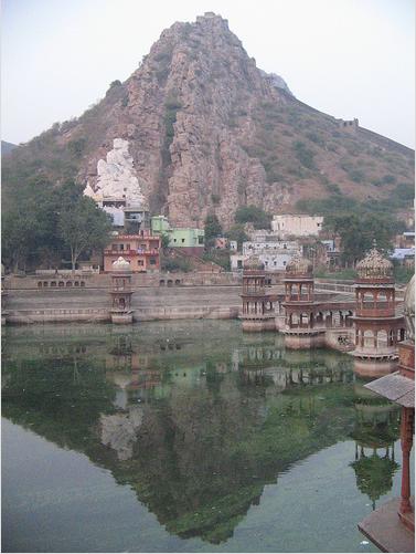
L'Âlwâr était, avant sa création, une partie de la principauté de Jaipur. La principauté est fondée par Pratap Singh (1740-1791), un râjput d'une ancienne lignée, râja de Macheri qui reçoit les titre de Râo Râja et Panch Hazari Mansab de l'empereur moghol Shâh Âlam II. L'État princier d'Alwar subsista jusqu'en 1948, date à laquelle il fut intégré à l'Etat du Matsya puis du Rajasthan en 1949.

Le territoire est étendu par son fils adoptif Bakhtawar Singh. Ce dernier s'allie aux Britanniques contre les Marathes, et en 1803, après la bataille de Laswari du 1er novembre, signe un traité d'alliance défensive et offensive avec le gouvernement britannique.

Quelques années plus tard, suite à son intervention armée à Jaipur, un nouveau traité est signé lui interdisant toute ingérence dans la politique des autres principautés sans l'accord des Britanniques.

Au cours de la révolte des Cipayes, en 1857, le râja Banni Singh envoie une force composée de musulmans et de Râjputs pour relever la garnison britannique d'Âgrâ, mais les musulmans désertèrent et les Râjputs furent défaits par les mutins.

Dirigeants : Râo Râja puis Mahârâja

Ex-principauté d'Âlwâr
Alwar flag.svg
Fondateur Pratap Singh
Fondée en 1771
Clan Naruka Lalawat
Religion hindoue
Superficie 8 179 km²
Salve 15 coups de canon
  • Râo Râja
    • 1775 - 1791 : Pratap Singh (1740-1791)
    • 1791 - 1815 : Bakhtawar Singh (1779-1815)
    • 1815 - 1826 : Banni Singh (+1845)
    • 1815 - 1857 : Balvant Singh (1806-1857), conjointement avec Banni Singh
    • 1857 - 1874 : Sheodan Singh (1845-1874)
    • 1874 - 1889 : Mangal Singh (1859-1892)
  • Mahârâja
    • 1889 - 1892 : Mangal Singh
    • 1892 - 1937 : Jai Singh (1882-1937)
    • 1937 - 1948 : Tej Singh (1911-2009)

Chef de la Maison Royale d'Alwar (maharadjah titulaire)

    • 1948 - 2009 : Tej Singh
    • 2009 -  : Jitendra Pratap Singh, né en 1971


Voir aussi

Liens externes


Wikimedia Foundation. 2010.

Contenu soumis à la licence CC-BY-SA. Source : Article District d'Âlwâr de Wikipédia en français (auteurs)

Игры ⚽ Нужна курсовая?

Regardez d'autres dictionnaires:

  • Alwar — Original name in latin Alwar Name in other language Alvar, Alvaras, Alvaro, Alwar, Alwar City, District d Alwar, District d lwr, a er wa er, alaraara, alavara, alvar, alvara, alvari, alwar, lvaro, Алвар State code IN Continent/City Asia/Kolkata… …   Cities with a population over 1000 database

  • Alwar — is a city in the Rajasthan state of western India. It is the administrative headquarters of Alwar District, and was formerly the capital of the princely state of Alwar or Ulwar in British India. The city is located around 160 km south of Delhi,… …   Wikipedia

  • Alwar district — is a district in Rajasthan, a state in northern India, near the city of Alwar. The district is bounded on the north by Haryana state, and on the east by Bharatpur, on the south by Dausa, and on the west by Jaipur districts.History of Alwar: The… …   Wikipedia

  • Mahendragarh district — महेन्‍द्रगढ जिला Location of Mahendragarh district in Haryana State …   Wikipedia

  • Dausa district — This article is about the district. For its eponymous headquarters, see Dausa. 28. Dausa district in Rajasthan Dausa District is a district of Rajasthan state in western India. The city of Dausa is the district headquarters. Dausa District has a… …   Wikipedia

  • Nagaur district — This article is about the district. For its eponymous headquarters, see Nagaur. 16. Location in Rajasthan Nagaur District is one of the 33 districts of the state of Rajasthan in western India. Area of the district is 17,718 km2. The city of… …   Wikipedia

  • Churu district — This article is about the district. For its eponymous headquarters, see Churu. Churu District in Rajasthan Churu is a district of Rajasthan state of western India. The town of Churu is the administrative headquarters of the district. Churu lies… …   Wikipedia

  • Mewat District — मेवात जिला Location of Mewat district in Haryana State Haryana …   Wikipedia

  • Chittorgarh district — This article is about the district. For its eponymous headquarters, see Chittorgarh. Not to be confused with Chittoor district. Chittorgarh District is a district of Rajasthan state in western India. The historic city of Chittorgarh is the… …   Wikipedia

  • Dungarpur district — is a district of the state of Rajasthan in western India. The town of Dungarpur is the district headquarters. Contents 1 History 2 Geography 3 Economy 4 …   Wikipedia

Share the article and excerpts

Direct link
Do a right-click on the link above
and select “Copy Link”