Braeriach
- Braeriach
-
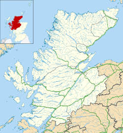
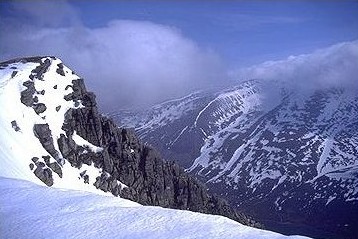
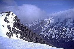
Le Braeriach (gaélique : Bràigh Riabhach/Am Bràigh Riabhach) est le troisième plus haut sommet de Grande-Bretagne, après le Ben Nevis et le Ben Macdhui avec ses 1 296 m d'altitude. C'est le sommet le plus élevé du massif des Cairngorms, séparé de la partie centrale (qui comprend le Ben Macdui et le Cairn Gorm) par le passage de Lairig Ghru. Ce sommet a une forme de croissant, avec plusieurs cirques. Dans le cirque de Garbh Coire Mor, sur la face nord, la neige a complétement fondu seulement cinq fois au siècle dernier : 1933, 1959, 1996, 2003 et 2006[1].
Références
- ↑ Royal Meteorological Society, Weather, mars 2007, vol. 62, n°3
Wikimedia Foundation.
2010.
Contenu soumis à la licence CC-BY-SA. Source : Article Braeriach de Wikipédia en français (auteurs)
Regardez d'autres dictionnaires:
Braeriach — Blick vom Sgor Gaoith über Glen Einich auf den Braeriach. Höhe 1.296 … Deutsch Wikipedia
Braeriach — Infobox Mountain Name = Braeriach Photo = Braeriach.jpg Caption = Braeriach seen from Sgor Gaoith, across Glen Einich Elevation = 1296 m (4252 ft) Location = Cairngorms, Scotland Prominence = 461 m Parent peak = Ben Macdui Coordinates =… … Wikipedia
Lairig Ghru — The northern entrance to the Lairig Ghru, with Lurcher s Crag (left) and Braeriach (right) The Lairig Ghru (Scottish Gaelic: Làirig Dhrù) is one of the mountain passes through the Cairngorms of Scotland. Like many traditional routes the ends of… … Wikipedia
Cairngorms — 57°05′N 3°40′W / 57.083, 3.667 … Wikipédia en Français
Cairn Toul — Blick auf den Cairn Toul vom Braeriach. Höhe 1.291 … Deutsch Wikipedia
Cairn Toul — Vue du Cairn Toul depuis le Braeriach, avec le Lochan Uaine. Géographie Altitude 1 291 m Massif … Wikipédia en Français
Cairngorms — This article is about the Scottish mountain range. For other uses, see Cairngorm. The Cairngorms are a mountain range in the eastern Highlands of Scotland closely associated with the mountain of the same name Cairn Gorm. The Cairngorms from Càrn… … Wikipedia
Cairn Toul — Infobox Mountain Name = Cairn Toul Photo = Cairn toul.jpg Caption = Cairn Toul from Braeriach, with Lochan Uaine Elevation = 1291 m (4236 ft) Location = Cairngorms, Scotland Range = Prominence = c. 166 m Topographic OS Landrangers 36, 43 Grid ref … Wikipedia
River Dee, Aberdeenshire — For other places with the same name, see River Dee (disambiguation). River Dee (Uisge Dè) River … Wikipedia
List of mountains and hills of the United Kingdom — This is a links page to the hills and mountains to be found in the United Kingdom (England, Northern Ireland, Scotland, and Wales), and includes lists of the highest mountains in each of the constituent countries. The ten highest mountains in the … Wikipedia
 Royaume-Uni
 Écosse