Brancaster
- Brancaster
-
52° 57′ 44″ N 0° 38′ 29″ E / 52.96219, 0.64132
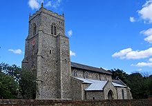
L'église Sainte-Marie de Brancaster.
Brancaster est un village et une paroisse civile du Norfolk, en Angleterre. Il se situe sur la côte nord de ce comté, à 35 km au nord-est de King's Lynn. Au moment du recensement de 2001, il comptait 897 habitants.
La localité est occupée depuis l'Antiquité : un fort romain nommé Branodunum y est édifié au IIIe siècle pour surveiller l'entrée du Wash, s'inscrivant dans le réseau de fortifications de la Côte saxonne.
Sur les autres projets Wikimedia :
Wikimedia Foundation.
2010.
Contenu soumis à la licence CC-BY-SA. Source : Article Brancaster de Wikipédia en français (auteurs)
Regardez d'autres dictionnaires:
Brancaster — is a village and civil parish on the north coast of the English county of Norfolk. The civil parish of Brancaster comprises Brancaster itself, together with Brancaster Staithe and Burnham Deepdale. The three villages form a more or less… … Wikipedia
Whirled into Happiness — Florence and the bogus Lord Brancaster Whirled into Happiness is a musical comedy with music by Robert Stolz, and book and lyrics by Harry Graham, adapted from Stolz s Der Tanz ins Glück, with a libretto by Robert Bodanzky and Bruno Hardt Warden … Wikipedia
A149 road — UK road routebox road= A149 length mi= 85.2 length km= direction= West to east start= Kings Lynn destinations= Cromer end= Great Yarmouth construction date= completion date= junctions= ukroadsmall|10 ukroadsmall|47 ukroadsmall|148 ukroadsmall|140 … Wikipedia
Litus Saxonicum — Die Ruine des spätrömischen Kastells Anderitum beim heutigen Pevensey/Südengland. Als Sachsenküste (lateinisch: litus Saxonicum) bezeichneten die Römer eine Kette von stark befestigten Militärlagern entlang der Süd und Südostküste von Britannien… … Deutsch Wikipedia
Sachsenküste — Als Sachsenküste, lateinisch Litus Saxonicum, bezeichneten die Römer eine Kette stark befestigter Militärlager und Flottenstationen entlang der Süd und Südostküste von Britannien (dem heutigen England) und an der Kanalküste bis zur Atlantikküste… … Deutsch Wikipedia
Saxon Shore Forts — Die Ruine des spätrömischen Kastells Anderitum beim heutigen Pevensey/Südengland. Als Sachsenküste (lateinisch: litus Saxonicum) bezeichneten die Römer eine Kette von stark befestigten Militärlagern entlang der Süd und Südostküste von Britannien… … Deutsch Wikipedia
Saxon Shore — The Saxon Shore (Latin: litus Saxonicum) was a military command of the late Roman Empire, consisting of a series of fortifications on both sides of the English channel. It was established in the late 3rd century and was led by the Count of the… … Wikipedia
The Norfolk Burnhams — are a group of adjacent villages on the north coast of Norfolk, England. The villages are located at the sea near a large natural bay named Brancaster Bay and the Scolt Head Island National Nature Reserve.A medieval verse speaks of London York… … Wikipedia
Scolt Head Island — is an offshore barrier island near Brancaster, north Norfolk, England, (but within the neighbouring parish of Burnham Norton) located 10 km west of Wells next the Sea. It is a National Nature Reserve. It is steadily growing westwards toward the… … Wikipedia
Côte saxonne — La Côte saxonne (latin : litus Saxonicum) était un commandement militaire de l Empire romain tardif, constitué d une série de fortifications sur les deux rives de la Manche. À la fin du IVe siècle, il fut limité à la seule Bretagne, les … Wikipédia en Français

