District de Dungarpur

District de Dungarpur

23° 50′ N 73° 43′ E / 23.83, 73.72

District de Dungarpur
Rajastan Dungarpur district.png
Administration
Pays Drapeau d'Inde Inde
Type District
État Rajasthan
Siège administratif Dungarpur
Géographie
Superficie 3 770 km2
Population
Population 1 107 037 hab. (2001)
Densité 293,6 hab./km2

Le district de Dungarpur (jusqu'en 1949 principauté de Dungarpur) est une division administrative de l'état indien du Rajasthan.

Sommaire

Histoire de la principauté

Les dirigeants de Dungarpur prétendent descendre du clan Râjput Sisodia du Mewâr. À la fin du XIIe siècle, Samant Singh, le fils aîné du râja du Mewâr dut quitter le royaume en faveur de son frère cadet Kumar Singh. Samant Singh s'installa dans le pays de Bagar et dans les siècles qui suivirent ses descendants contrôlèrent toute la région.

Udai Singh de Bagar fut tué à la bataille de Khanua en 1527, luttant au sein d'une coalition de Mewâr contre l'empereur moghol Bâbur. Son territoire sera partagé entre ses deux fils, devenant deux états indépendants, Prithvi Raj restant à Dungarpur tandis que son frère Jagmal Singh prenait la tête du Bânsvâra.

La principauté subsista jusqu'en 1949 puis a été intégrer l'État du Rajasthan.

Dirigeants : Râwal puis Mahârâwal

Ex-principauté
de Dungarpur
Drapeau non dispo.png
Fondateur Samant Singh
Fondée en 1197
Clan Râjput Sisodia
Religion hindoue
Superficie 3781 km² km²
Salve 15 coups de canon
  • Râwal
    • 1197 – 1209 : Samant Singh
    • 1209 - 1218 : Jayat Singh
    • 1218 - 1248 : Sinhad Deo
    • 1248 - 1251 : Jay Singh Deo
    • 1251 - 1278 : Deopali Deo
    • 1278 - 1303 : Virsinh Deo
    • 1303 - 1331 : Bhoo Chand
    • 1331 - 1363 : Dungar Singh
    • 1363 - 1384 : Karan Singh I
    • 1384 - 1386 : Jaykrishna
    • 1386 - 1398 : Mahipal Singh I
    • 1398 - 1403 : Kanhad Deo
    • 1403 - 1423 : Pratap Singh
    • 1423 - 1447 : Gopinath Singh
    • 1447 - 1479 : Soma Das
    • 1479 - 1497 : Ganga Das
    • 1497 - 1527 : Udai Singh I
    • 1527 - 1549 : Prithviraj Singh
    • 1549 - 1580 : Askaran Singh
    • 1580 - 1606 : Sahas Mal
    • 1606 - 1609 : Karan Singh II
    • 1609 - 1657 : Punjaraj Singh
    • 1657 - 1661 : Girdhar Das
    • 1661 - 1691 : Jeswant Singh I
    • 1691 - 1702 : Khuman Singh
    • 1702 - 1730 : Ram Singh
    • 1730 - 1785 : Shiv Singh
    • 1785 - 1790 : Vairi Sal
    • 1790 - 1808 : Fateh Singh (+1808)
  • Mahârâwal
    • 1808 - 1845 : Jeswant Singh II (+1845)
    • 1846 - 1898 : Udai Singh II (1838-1898)
    • 1898 - 1918 : Bijai Singh (1887-1918)
    • 1918 - 1949 : Lakshman Singh (1908-1989)

Voir aussi

Lien externe

Série Histoire monde indien
Cet article fait partie de la série
Histoire de l'Inde
Périodes
Inde ancienne
Sultanat de Delhi
Grands Moghols
Période Marathe
Inde britannique
Raj britannique
De 1947 à nos jours
Voir aussi
Histoire du Bangladesh
Histoire du Bhoutan
Histoire des Maldives
Histoire du Népal
Histoire du Pakistan
Histoire du Sri Lanka
Articles connexes
Langues de l'Inde
Religions de l'Inde
Méta
Portail Monde indien
Index alphabétique
Index thématique

Wikimedia Foundation. 2010.

Contenu soumis à la licence CC-BY-SA. Source : Article District de Dungarpur de Wikipédia en français (auteurs)

Игры ⚽ Поможем написать реферат

Regardez d'autres dictionnaires:

  • Dungarpur district — is a district of the state of Rajasthan in western India. The town of Dungarpur is the district headquarters. Contents 1 History 2 Geography 3 Economy 4 …   Wikipedia

  • Dungarpur — Vue aérienne 
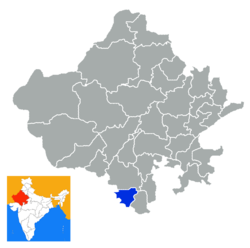
Administration Pays  Inde …   Wikipédia en Français

  • Dungarpur — This article is about the municipality in Rajasthan, India. For its namesake district, see Dungarpur district. Dungarpur   city   …   Wikipedia

  • Banswara district — has an area of 5,037 km², 1.47% of Rajasthan state, India. The city of Banswara is the district headquarters. It is bounded on the north by Udaipur District, on the northeast by Chittorgarh District, on the east and southeast by Madhya Pradesh… …   Wikipedia

  • Chittorgarh district — This article is about the district. For its eponymous headquarters, see Chittorgarh. Not to be confused with Chittoor district. Chittorgarh District is a district of Rajasthan state in western India. The historic city of Chittorgarh is the… …   Wikipedia

  • Nagaur district — This article is about the district. For its eponymous headquarters, see Nagaur. 16. Location in Rajasthan Nagaur District is one of the 33 districts of the state of Rajasthan in western India. Area of the district is 17,718 km2. The city of… …   Wikipedia

  • Dausa district — This article is about the district. For its eponymous headquarters, see Dausa. 28. Dausa district in Rajasthan Dausa District is a district of Rajasthan state in western India. The city of Dausa is the district headquarters. Dausa District has a… …   Wikipedia

  • Churu district — This article is about the district. For its eponymous headquarters, see Churu. Churu District in Rajasthan Churu is a district of Rajasthan state of western India. The town of Churu is the administrative headquarters of the district. Churu lies… …   Wikipedia

  • Dholpur district — This article is about the district. For its eponymous headquarters, see Dholpur. Dholpur District is a district of Rajasthan state in western India. The town of Dholpur is the district headquarters. Dholpur District has an area of 3084 km².… …   Wikipedia

  • Dahod District — Districts of central Gujarat Dahod District, also known as Dohad District, is located in Gujarat state in western India. The city of Dahod is the district s administrative headquarters. The district has an area of 3,642 km², and a population of 1 …   Wikipedia

Share the article and excerpts

Direct link
Do a right-click on the link above
and select “Copy Link”