District de Jalore
- District de Jalore
-
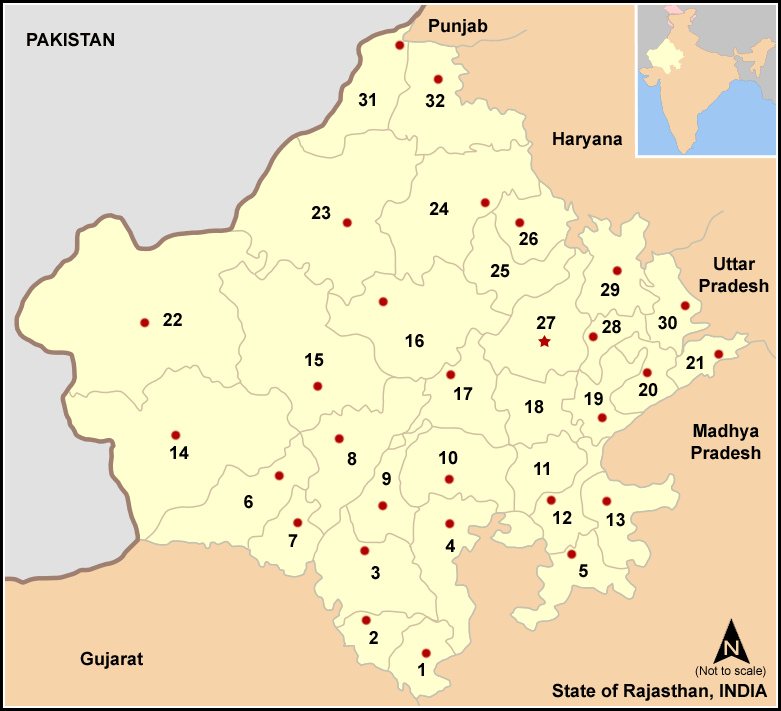
Le district de Jalore est un district de l'état du Rajasthan en Inde.
Wikimedia Foundation.
2010.
Contenu soumis à la licence CC-BY-SA. Source : Article District de Jalore de Wikipédia en français (auteurs)
Regardez d'autres dictionnaires:
Jalore — Infobox Indian Jurisdiction native name = Jalor | type = city | latd = 25.35 | longd = 72.62 locator position = right | state name = Rajasthan district = Jalor leader title = leader name = altitude = 178 population as of = 2001 population total … Wikipedia
Jalor district — is a district of Rajasthan state in western India. The city of Jalore is the administrative headquarters of the district. The district has an area of 10,640 km² (3.11 percent of Rajasthan s area), and a population of 1,448,486 (2001 census), with … Wikipedia
Nagaur district — This article is about the district. For its eponymous headquarters, see Nagaur. 16. Location in Rajasthan Nagaur District is one of the 33 districts of the state of Rajasthan in western India. Area of the district is 17,718 km2. The city of… … Wikipedia
Churu district — This article is about the district. For its eponymous headquarters, see Churu. Churu District in Rajasthan Churu is a district of Rajasthan state of western India. The town of Churu is the administrative headquarters of the district. Churu lies… … Wikipedia
Chittorgarh district — This article is about the district. For its eponymous headquarters, see Chittorgarh. Not to be confused with Chittoor district. Chittorgarh District is a district of Rajasthan state in western India. The historic city of Chittorgarh is the… … Wikipedia
Dungarpur district — is a district of the state of Rajasthan in western India. The town of Dungarpur is the district headquarters. Contents 1 History 2 Geography 3 Economy 4 … Wikipedia
Dausa district — This article is about the district. For its eponymous headquarters, see Dausa. 28. Dausa district in Rajasthan Dausa District is a district of Rajasthan state in western India. The city of Dausa is the district headquarters. Dausa District has a… … Wikipedia
Dholpur district — This article is about the district. For its eponymous headquarters, see Dholpur. Dholpur District is a district of Rajasthan state in western India. The town of Dholpur is the district headquarters. Dholpur District has an area of 3084 km².… … Wikipedia
Modran Jalore District — Modran is in Jalore District of Rajasthan. It is around 9 km to the south of Bakra and 15 km to the west of Bagra. The nearest town is Bara, 4 km to the south. Eighteen kilometers to the north west is Saila.Jalore Fort, Mosque of Saint Malik Shah … Wikipedia
Pali district — (पाली जिला) is a district of the state of Rajasthan in western India. The town of Pali is the district headquarters.The Aravalli Range forms the eastern boundary of the district. A zone of foothills lies to the west, through which run the many… … Wikipedia
 Inde
Inde