Fioletovo
- Fioletovo
-
40° 43′ 29″ N 44° 42′ 50″ E / 40.724722, 44.713889
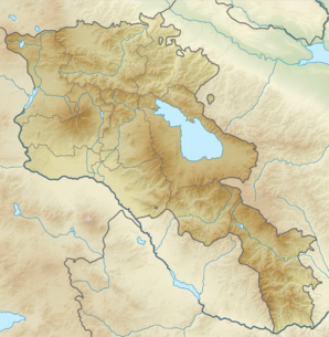
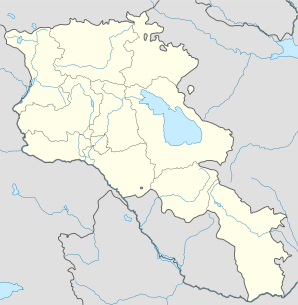
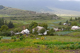
Fioletovo (en arménien Ֆիոլետովո ; jusqu'en 1936 Nikitino[2]) est une communauté rurale du marz de Lorri en Arménie. En 2008, elle compte 1 394 habitants[3].
Notes et références
- ↑ (hy+en) Central Electoral Commission of the Republic of Armenia. Consulté le 24 janvier 2011.
Pour obtenir la page en anglais, cliquez sur le drapeau arménien en haut à gauche, et sélectionnez « English » ; ensuite, dans le menu vertical de gauche, cliquez sur « Local », sélectionnez le
marz pertinent, puis la dernière élection correspondant à la communauté voulue.
- ↑ (en) Brady Kiesling, Rediscovering Armenia, 2000 [lire en ligne (page consultée le 25 mars 2010)] .
- ↑ (en) ArmStat, Marzes of the Republic of Armenia in figures, 2008, « RA Lori Marz », 2008. Consulté le 20 septembre 2009.
Sur les autres projets Wikimedia :
Wikimedia Foundation.
2010.
Contenu soumis à la licence CC-BY-SA. Source : Article Fioletovo de Wikipédia en français (auteurs)
Regardez d'autres dictionnaires:
Fioletovo — Coordinates: 40°43′29″N 44°42′50″E / 40.72472°N 44.71389°E / 40.72472; 44.71389 … Wikipedia
Fioletovo — Original name in latin Fioletovo Name in other language Fioletovo, Nikitino, Фиолетово State code AM Continent/City Asia/Yerevan longitude 40.72241 latitude 44.71769 altitude 1686 Population 1264 Date 2012 01 17 … Cities with a population over 1000 database
Molokan — Molokans (Russian for milk drinkers : молокане) are sectarian Christians who evolved from Spiritual Christian Russian peasants that refused to obey the Russian Orthodox Church, beginning in the 17th century. They were so named for their drinking… … Wikipedia
List of places named after people — There are a number of places named after famous people. For more on the general etymology of place names see toponomy. For other lists of eponyms (names derived from people) see eponym.Continents*Americas (North America and South America) ndash;… … Wikipedia
Odzun — Օձուն … Wikipedia
Vanadzor — Seal … Wikipedia
Ivan Fioletov — Ivan Timofeevich Fioletov (1884 1918) was a Russian Communist activist, one of the Bolshevik Party leaders in Azerbaijan during the Russian Revolution. Fioletov was born into a poor peasant family in Borisoglebsk, a town in nowadays Voronezh… … Wikipedia
Akhtala — For the town in Kotayk Province, see Hrazdan; for the nearby town sometimes also called Akhtala, see Verin Akhtala. Coordinates: 41°08′N 44°46′E / 41.133°N 44.767°E … Wikipedia
Piknik — Infobox musical artist Name = Piknik. Background = group or band Origin = flagicon|USSR Sankt Peterburg, Russian SFSR Genre = Russian rock, Art rock, Progressive rock, Jazz rock Years active = 1978–present URL = [http://www.piknik.info/ Piknik… … Wikipedia
Arevashogh — Coordinates: 40°51′41″N 44°16′22″E / 40.86139°N 44.27278°E / 40.86139; 44.27278 … Wikipedia
 Arménie