- Northern Limit Line
-
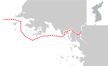 Localisation de la Northern Limit Line.
La Northern Limit Line (souvent abrégé en « NLL », en français : « ligne de limite nord ») constitue de facto la partie maritime occidentale de la frontière intercoréenne séparant les deux États antagonistes que sont la Corée du Nord et la Corée du Sud. Elle est située en mer Jaune, au sud du Golfe de Corée.
Sommaire
Localisation
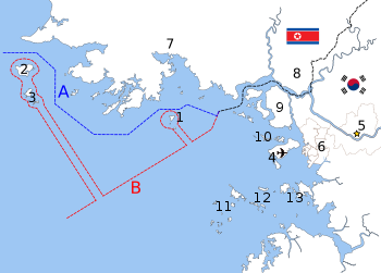 La frontière maritime disputée entre les Corées du Nord et du Sud en mer Jaune [1]:
En bleu A : la Northern Limit Line créée par les Nations-Unies en 1953 et rejetée à partir de 1973 par la Corée du Nord[2]
En rouge B : la ligne de démarcation déclarée par la Corée du Nord en 1999[3]. La localisation des îles spécifiques se reflète dans la configuration de chaque frontière maritime, incluant :
1. Yeonpyeong, 2. Baengnyeong, 3. Daecheong, 4. Aéroport international d'Incheon, 5. Seoul, 6. Incheon, 7. Haeju, 8. Kaesong, 9. île de Kanghwa, 10. île de Bukdo Myeon, 11. île de Deokjeokdo, 12. île de Jawol Myeon, 13. île de Yeongheung Myeon.Cette ligne de démarcation maritime (frontière) débute à l'est à l'embouchure du fleuve Han et de la rivière Imjin, puis continue vers l'ouest en longeant les côtes sud-ouest de la Corée du Nord. Ainsi plusieurs îles contrôlées par les autorités de Séoul comme : Yeonpyeong, Baengnyeong ou Daecheong, peuvent se trouver parfois à moins de 40 km des côtes nord-coréennes (Yeonpyeong est même à 10 km des côtes de Corée du Nord)..
Histoire
Article détaillé : Guerre du Crabe.La ligne a été tracée juste après l'armistice de la guerre de Corée en 1953 par les Nations unies qui ont envoyé les plans à la Corée du Nord. Celle-ci n'ayant pas répondu, l'ONU a considéré qu'elle avait accepté ce tracé. En 1973, la Corée du Nord à déclarer ne pas reconnaitre sa légitimité et, en 1999, elle a rendu public le tracé qu'elle revendiquait.
Cette zone riche en crustacés, notamment en crabes, est actuellement un endroit très disputé entre les deux pays. Cette rivalité dégénérant souvent en de nombreux incidents armés depuis 1999 que l'on qualifie de « guerre du Crabe ». En 2010, il y eut ainsi au total près d'une dizaine d'affrontements autour de cette ligne de démarcation.
Annexes
Notes et références
- Ryoo, Moo Bong."The Korean Armistice and the Islands," p. 13 ( PDF, p. 21). Strategy research project at the U.S. Army War College, 3 novembre 2009, consulté le 16 décembre 2010
- "Factbox: What is the Korean Northern Limit Line?" Reuters (UK). November 23, 2010; retrieved 26 Nov 2010.
- "NLL—Controversial Sea Border Between S.Korea, DPRK, " People's Daily (République populaire de Chine), 21 novembre 2002; consulté le 16 décembre 2010.
Articles connexes
- Zone coréenne démilitarisée
- Guerre du Crabe, conflit maritime entre les deux Corées
- Frontière entre la Corée du Nord et la Corée du Sud
Liens externes
- (en) Les engagements navals près de la Northern Limit Line
- (en) Les problèmes de la ligne de démarcation maritime en mer Jaune
 Portail du monde maritime
 Portail de la géographie
 Portail de la Corée
Catégories :- Frontière maritime dans l'océan Pacifique
- Frontière de Corée du Nord
- Frontière de Corée du Sud
- Frontière maritime contestée


Wikimedia Foundation. 2010.