Gaweinstal
Contenu soumis à la licence CC-BY-SA. Source : Article Gaweinstal de Wikipédia en français (auteurs)
Regardez d'autres dictionnaires:
Gaweinstal — Gaweinstal … Deutsch Wikipedia
Gaweinstal — Infobox Town AT name=Gaweinstal name local= image coa = Wappen Gaweinstal.gif state = Lower Austria regbzk = district = Mistelbach population =3485 population as of = 2001 population ref = pop dens = area = 51.6 elevation = 199 lat deg=48 lat min … Wikipedia
Gaweinstal — Original name in latin Gaweinstal Name in other language Gaweinstal State code AT Continent/City Europe/Vienna longitude 48.46667 latitude 16.58333 altitude 205 Population 0 Date 2011 07 31 … Cities with a population over 1000 database
Gaweinstal — Sp Gãveinstalis Ap Gaweinstal L Austrija … Pasaulio vietovardžiai. Internetinė duomenų bazė
Liste der denkmalgeschützten Objekte in Gaweinstal — Die Liste der denkmalgeschützten Objekte in Gaweinstal enthält die denkmalgeschützten, unbeweglichen Objekte der Gemeinde Gaweinstal, wobei die Objekte teilweise per Bescheid und teilweise durch den § 2a des Denkmalschutzgesetzes unter… … Deutsch Wikipedia
Atzelsdorf (Gemeinde Gaweinstal) — Wappen Karte … Deutsch Wikipedia
Martinsdorf (Gemeinde Gaweinstal) — Wappen Karte … Deutsch Wikipedia
Pellendorf (Gemeinde Gaweinstal) — Wappen Karte … Deutsch Wikipedia
Schrick (Gemeinde Gaweinstal) — Wappen Karte … Deutsch Wikipedia
Gaunersdorf — Wappen Karte … Deutsch Wikipedia


 Autriche
 Basse-Autriche
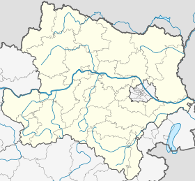

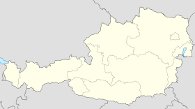
 Gaweinstal


