Gravesham

Gravesham
Borough de Gravesham
District dans le Kent
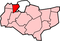
Géographie
Status: Borough
Région: Angleterre du Sud-Est
Comté: Kent
Comté historique: Kent
Superficie:
- Total
Classé 221e
99.02 km²
Centre administatif: Gravesend
Code ONS: 29UG
Démographie
Population:
-Total (2010)
-Densité
Classé 226e
99.600
1,005.9 / km²
Ethnicité: 87.8% Blanc
8.5% Asiatique
1.4% Noir
1.3% Race Mixe
1.0% Chinois
Politique
Borough de Gravesham
http://www.gravesham.gov.uk/
Leadership: Leader & Cabinet
Exécutif : Conservateur
MPs: Adam Holloway

Gravesham est un District non-métropolitain et un Borough situé dans le Nord-Ouest du Kent, en Angleterre. Elle a des frontières avec la Tamise au nord, les villes de Rochester et Medway à l'Est, les Borough de Tonbridge et Malling au Sud et les Borough de Sevenoaks et Dartford à l'Ouest.

Son conseil est basé à la mairie de Gravesend.

Liste des 6 paroisses constituant le district

Liens externes


Wikimedia Foundation. 2010.

Contenu soumis à la licence CC-BY-SA. Source : Article Gravesham de Wikipédia en français (auteurs)

Игры ⚽ Нужен реферат?

Regardez d'autres dictionnaires:

  • Gravesham — is a local government district and borough in the north west of Kent, England. It has borders with The River Thames to the north; the city of Medway to the east; the borough of Tonbridge and Malling (to the south); and the boroughs of Sevenoaks… …   Wikipedia

  • Gravesham — Distrito del Reino Unido Ubicación en el condado de Kent …   Wikipedia Español

  • Gravesham — Borough of Gravesham Lage in Kent Status Borough Region South East England Verw.grafschaft Kent …   Deutsch Wikipedia

  • Gravesham (UK Parliament constituency) — UK constituency infobox Name = Gravesham Map1 = Gravesham Map2 = Kent Entity = Kent Type = County Year = 1983 Entity = Kent County = Kent EP = South East England MP = Adam Holloway Party = ConservativeGravesham is a constituency represented in… …   Wikipedia

  • Gravesham — /grayv sheuhm/, n. a borough in NW Kent, in SE England. 95,329. * * * ▪ district, England, United Kingdom       borough (district), administrative and historic county of Kent, southeastern England. Its centre is the town of Gravesend, but it… …   Universalium

  • Gravesham — /grayv sheuhm/, n. a borough in NW Kent, in SE England. 95,329 …   Useful english dictionary

  • Hook Green, Gravesham — infobox UK place country = England official name= Hook Green latitude= 51.413 longitude= 0.317 population = shire district= Dartford shire county = Kent region= South East England Ambulance= constituency westminster= post town= postcode district …   Wikipedia

  • Gravesend, Kent — Long Reach redirects here. For the neighbourhood in the eastern United States, see Long Reach, Columbia, Maryland. Coordinates: 51°26′29″N 0°22′07″E / 51.4415°N 0.3685°E …   Wikipedia

  • Northfleet — For the ship wrecked on January 22, 1873, see Northfleet (ship). Coordinates: 51°26′51″N 0°19′29″E / 51.447588°N 0.324783°E / …   Wikipedia

  • Meopham — Coordinates: 51°21′50″N 0°21′36″E / 51.364°N 0.360°E / 51.364; 0.360 …   Wikipedia

Share the article and excerpts

Direct link
Do a right-click on the link above
and select “Copy Link”