Bağcılar
- Bağcılar
-
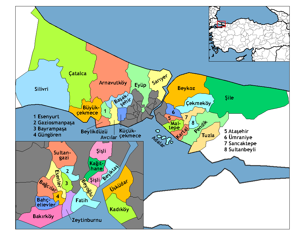
Bağcılar est un district d'Istanbul en Turquie. Situé sur la partie européenne de la ville, entre les deux grandes rocades, le TEM et le E5, Bağcılar est une banlieue ouvrière.
Campagne à faible densité de population au moment de la fondation de la République turque, Bağcılar signifie verger en turc. Les vergers ont aujourd'hui disparu.
Bağcılar est maintenant peuplée par les immigrants récents d'Anatolie, essentiellement des jeunes familles modestes.
Bağcılar abrite des industries, en particulier mécanique légère, textile et imprimerie (Bağcılar est le foyer de grands journaux et chaînes de télévision turcs), un immense marché de gros de produits secs, un grand marche de voitures d'occasion marché et de nombreux entreprises de transport, en particulier le long de la route Gunesli entre l'autoroute TEM et l'aéroport international Atatürk d'Istanbul. Un métro est en cours de construction.
Notes et références
Sur les autres projets Wikimedia :
Lien externe
Wikimedia Foundation.
2010.
Contenu soumis à la licence CC-BY-SA. Source : Article Bağcılar de Wikipédia en français (auteurs)
Regardez d'autres dictionnaires:
Bagcilar — Bağcılar Bağcılar Administration Pays … Wikipédia en Français
Bağcılar — Saltar a navegación, búsqueda Bağcılar Datos País Turquía … Wikipedia Español
Bağcılar — is a working class suburb of İstanbul, Turkey. Located behind Bahcelievler on the European side of the city, between the two major ring roads, the TEM and the E5.Sparsely populated countryside at the time of founding of the Turkish republic,… … Wikipedia
Bağcılar — Vorlage:Infobox Ort in der Türkei/Wartung/LandkreisVorlage:Infobox Ort in der Türkei/Wartung/LandkreisOhneEinwohnerOderFläche Bağcılar … Deutsch Wikipedia
Bagcilar — Original name in latin Baclar Name in other language Badzilaras rajons, Bagcilar, Bagdzhylar, Baclar, Bdilaras rajons, Cifitburgaz, Ciftburgaz, iftburgaz, ftburgaz, Багджылар State code TR Continent/City Europe/Istanbul longitude 41.03903… … Cities with a population over 1000 database
Bagcilar — Admin ASC 2 Code Orig. name Bağcılar Country and Admin Code TR.34.7732460 TR … World countries Adminstrative division ASC I-II
Bağcılar Olympic Sport Hall — Infobox Stadium|stadium name=Bağcılar Olympic Sport Hall location=Fevzi Çakmak Mah. Fatih Cad.50/A Bağcılar, Istanbul opened= 2001 owner= Istanbul Metropolitan Municipality operator= architect= tenants= seating capacity= 1,300 (main hall), 3,500… … Wikipedia
Bağcılar — is., öz. İstanbul iline bağlı ilçelerden biri … Çağatay Osmanlı Sözlük
Beyoglu — Die größte Stadt der Türkei, Istanbul, erstreckt sich über etwa 50 Kilometer in west östlicher wie in nord südlicher Richtung und wird durch den Bosporus in eine europäische und eine asiatische Seite geteilt. Das alte, im Süden der europäischen… … Deutsch Wikipedia
Demonesi — Die größte Stadt der Türkei, Istanbul, erstreckt sich über etwa 50 Kilometer in west östlicher wie in nord südlicher Richtung und wird durch den Bosporus in eine europäische und eine asiatische Seite geteilt. Das alte, im Süden der europäischen… … Deutsch Wikipedia
 Turquie
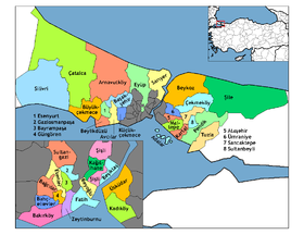
 Bağcılar