Interstate 880

Interstate 880
Interstate 880
I-880.svg
California Interstate 880.svg
Longueur 73,544 km (45,698 mi)
Ouverture 1930 (en tant que state highway)
1983-4 (en tant que interstate highway)
Direction sud / nord
Extrémité sud I-280 (CA).svgCalifornia 17.svg 
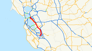
I-280 / SR 17 à San José
Intersections US 101.svg U.S. Route 101 à San José
California 84.svg SR 84 à Fremont
California 92.svg SR 92 à Hayward
I-238 (CA).svg Interstate 238 à San Leandro
I-980 (CA).svg Interstate 980 à Oakland
Extrémité nord I-80 (CA).svgI-580 (CA).svg I-80 / I-580 à Oakland
Réseau Interstate highway

L'Interstate 880 (I-880) est une Interstate highway située dans la Baie de San Francisco qui relie du sud au nord San José à Oakland en suivant le tracé de la côte. L'I-880 est nommée Nimitz Freeway sur la majeure partie de son tracé, en l'honneur de l'amiral américain Chester Nimitz, qui passa sa retraite dans la région de la Baie et vécut dans Yerba Buena Island. Cette autoroute fait partie du California Freeway and Expressway System.

Voir aussi

Autoroutes inter-États (principales en rose) Interstate Highway marker
4 5 8 10 12 15 16 17 19 20 22 24 25 26 27 29
30 35 37 39 40 43 44 45 49 55 57 59 64 65 66 68
69 70 71 72 73 74 75 76 (W) 76 (E) 77 78 79 80 81
82 83 84 (W) 84 (E) 85 86 (W) 86 (E) 87 88 (W) 88 (E)
89 90 91 93 94 95 96 97 99 (238) H-1 H-2 H-3
Autres A-1 A-2 A-3 A-4 PRI-1 PRI-2 PRI-3

Wikimedia Foundation. 2010.

Contenu soumis à la licence CC-BY-SA. Source : Article Interstate 880 de Wikipédia en français (auteurs)

Игры ⚽ Поможем решить контрольную работу

Regardez d'autres dictionnaires:

  • Interstate 880 — For the former Interstate 880 around Sacramento, now part of Interstate 80, see Interstate 880 (Sacramento, California). Interstate 880 Nimitz Freeway …   Wikipedia

  • Interstate 238 — Basisdaten Länge: 2,16 mi/3,48 km Bundesstaat: Kalifornien …   Deutsch Wikipedia

  • Interstate 980 (Kalifornien) — Basisdaten Länge: 2,02 mi/3,25 km Bundesstaat: Kalifornien Karte …   Deutsch Wikipedia

  • Interstate 80 — Basisdaten Länge: 2899 mi/4666 km Bundesstaaten: Kalifornien Nevada Utah Wyoming …   Deutsch Wikipedia

  • Interstate 980 — Basisdaten Länge: 2,02 mi/3,25 km Bundesstaat: Kalifornien …   Deutsch Wikipedia

  • Interstate 238 — Infobox road state=CA type=I route=238 section=538 maint=Caltrans length mi=2.16 length round=2 length ref= [http://www.dot.ca.gov/hq/structur/strmaint/brlog2.htm January 1, 2006 California Log of Bridges on State Highways] ] established=May 1983 …   Wikipedia

  • Interstate 980 — Infobox road state=CA route=980 type=I alternate name=Grove Shafter Freeway section=624 maint=Caltrans length mi=2.02 length round=2 length ref= [http://www.dot.ca.gov/hq/structur/strmaint/brlog2.htm January 1, 2006 California Log of Bridges on… …   Wikipedia

  • Interstate 80 in California — Infobox road state=CA type=I route=80 section=380 maint=Caltrans alternate name=Bayshore Freeway, Eastshore Freeway length mi=207.554 length round=3 length ref= established=August 7, 1947 by FHWA [http://cahighways.org/itypes.html California… …   Wikipedia

  • Interstate 280 (California) — Infobox road state=CA type=I route=280 alternate name=Junipero Serra Freeway, Sinclair Freeway section=580 maint=Caltrans length mi=56.88 length round=2 length ref= [http://www.dot.ca.gov/hq/structur/strmaint/brlog2.htm January 1, 2006 California …   Wikipedia

  • Interstate 580 (California) — Infobox road state=CA type=I route=580 alternate name=Eastshore Freeway, MacArthur Freeway, Brown Freeway section=618 maint=Caltrans length mi=79.97 length round=2 length ref=Fact|date=December 2007 established=August 7, 1947 by FHWA… …   Wikipedia

Share the article and excerpts

Direct link
Do a right-click on the link above
and select “Copy Link”