- Beatty Airport
-
Beatty (Nevada)
 Pour les articles homonymes, voir Beatty.
Beatty 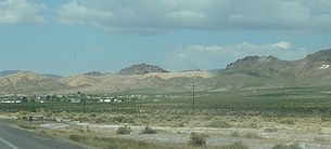
Pays  États-Unis
État  Nevada
Comté Comté de Nye 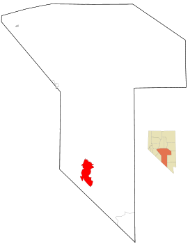
Localisation de BeattySuperficie 454,9 km² Superficie terrestre 454,9 km² Population (2000) 1154 hab. Densité 2,5 hab./km² Fuseau horaire PST (UTC – 8) Beatty est une localité du comté de Nye, au Nevada, États-Unis, située sur la rivière Amargosa. Sa population était de 1 154 habitants lors du recensement de 2000. La ville fut nommée du nom de Murray "Old Man" Beatty, qui installa un ranch dans cette zone à la fin du XIXe siècle. Il mourra en décembre 1908.
Sommaire
Géographie
Beatty est localisée à , à 3 320 pieds d'altitude.
Selon le bureau de recensement des États-Unis, la ville a une surface totale de 454,9 km².
Histoire
Beatty s'est développée dans le disctrict de Bullfrog durant la même période de la création de cinq autres hameaux miniers dans ses environs immédiats : Original Bullfrog, Amargosa, Bullfrog, Bonanza et Gold Center. Ces 6 hameaux ont donné naissance à la ville de Rhyolite qui a compté près de 10 000 habitants en 1907 puis qui a été abandonnée à partir de 1908. De ces villes, seule Beatty existe encore aujourd'hui.
Transports
Beatty posséde un aéroport (Beatty Airport, code AITA : BTY).
Liens externes
 Portail des États-Unis
Catégories : Ville du Nevada | Comté de Nye


Wikimedia Foundation. 2010.