Kömlőd
- Kömlőd
-
Kömlőd est un village et une commune du comitat de Komárom-Esztergom en Hongrie.
Géographie
Cette section est vide, insuffisamment détaillée ou incomplète.
Votre aide est la bienvenue !
Histoire
Cette section est vide, insuffisamment détaillée ou incomplète.
Votre aide est la bienvenue !
Catégorie :
- Ville et village du comitat de Komárom-Esztergom
Wikimedia Foundation.
2010.
Contenu soumis à la licence CC-BY-SA. Source : Article Kömlőd de Wikipédia en français (auteurs)
Regardez d'autres dictionnaires:
Kömlőd — Infobox Settlement subdivision type = Country subdivision name = HUN timezone=CET utc offset=+1 timezone DST=CEST utc offset DST=+2|official name=Kömlőd subdivision type1=County subdivision name1=Komárom Esztergom area total km2=22.83 population… … Wikipedia
Adam Paloczi Horvath — Ádam Pálóczi Horváth Ádam Pálóczi Horváth [ˈaːdaːm ˈpaːloːtsi ˈhorvaːt] (* 11. Mai 1760 in Kömlőd; † 28. Januar 1820 in Nagybajom) war ein ungarischer Volksmusiksammler, Dichter und Komponist. Über die Lebensumstände Horváths ist kaum etwas… … Deutsch Wikipedia
Komárom-Esztergom County — Infobox Hungarian county name =Komárom Esztergom region =Central Transdanubia seat = Tatabánya area = 2265 population = 319,000 density = 142 cities = 76Komárom Esztergom is the name of an administrative county (comitatus or megye) in northern… … Wikipedia
Oroszlány — Aerial view … Wikipedia
Dorog — Town … Wikipedia
German exonyms (Transylvania) — Below is a list of German language exonyms for towns and villages in Transylvania, Romania. The German names are listed first, followed by the Romanian and the Hungarian names. A * Abtsdorf (bei Marktschelken): Ţapu (Csicsóholdvilág) * Abtsdorf… … Wikipedia
Nyergesújfalu — Nyergesújfalu … Wikipedia
Milaş — Commune … Wikipedia
Dunakömlőd — Paks und Kömlőd (Kimling) auf einem Ausschnitt einer Karte von 1809. Zu sehen sind die Halbinsel Imsós, die sog. Überfahrt Imsós bei Zádor und die Battyán vára (Battyán Burg), an deren Stelle einst das römische Kastell Lussonium stand. Dunakömlőd … Deutsch Wikipedia
Liste deutscher Bezeichnungen rumänischer Orte — In dieser Liste werden Orte in Rumänien (Städte, Flüsse, Inseln etc.) mit ihren deutschen und ungarischen Namen angeführt. Vor dem Zweiten Weltkrieg rumänische Bezeichnungen, die geändert wurden, werden kursiv dargestellt. Der ungarische Name… … Deutsch Wikipedia


 Hongrie

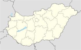
 Kömlőd


